Nucla geodata
Nucla (Colorado) is a populated place; located in United States in America/Denver (GMT-6) time zone. With population of 702 people, there are 18655 cities with bigger population in this country. Compared to other cities in United States, 60.1% of cities are located further ↑North; 85.2% of cities are located further →East and 98.3% of cities have lower elevation than Nucla. Note1


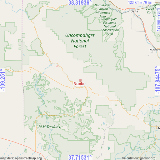
Nucla GPS coordinates[2]
38° 16' 9.948" North, 108° 32' 52.332" West
| Map corner | latitude | longitude |
|---|---|---|
| Upper-left | 38.81936°, | -109.251° |
| Center: | 38.26943°, | -108.54787° |
| Lower-right: | 37.71531°, | -107.84475° |
| Map W x H: | 122.8×122.8 km | = 76.3×76.3mi |
| max Lat: | 71.29058° ⇑60.1% North |
| Nucla: | 38.26943° |
| min Lat: | ⇓39.9% South 19.06759° |
| min Long | Nucla | max Long |
| -171.73463° | -108.54787° | -66.98998° |
| W 14.8%⇐ | ⇒85.2% E |
Elevation
Elevation of Nucla is 1769 m = 5804 ft, and this is 1474.2 m = 4837 ft above average elevation for this country.
| Max E: |
3189 m = 10463 ft | 1.7% |
| Nucla | 1769 m 5804 ft | |
| Avg. | 294.8 m = 967 ft | |
Min E: |
-60 m = -197 ft | 98.3% |
See also: United States elevation on elevation.city.
Geographical zone
Nucla is located in North temperate zone (between Tropic of Cancer and the Arctic Circle). Distance of this Northern Tropic circle is 1649.2 km =1024.8 mi to South.| Distance of | km | miles | from Nucla |
|---|---|---|---|
| North Pole | 5751.9 | 3574.1 | to North |
| Arctic Circle | 3146 | 1954.8 | to North |
| Tropic Cancer | 1649.2 | 1024.8 | to South |
| Equator | 4255.2 | 2644.1 | to South |


Nearby cities:
15 places around Nucla: (largest is in red/bold)
• Delta
67.1 km =41.7 mi,  38°
38°
• Dove Creek
64.2 km =39.9 mi,  209°
209°
• Grand Junction
88.3 km =54.9 mi,  359°
359°
• Loghill Village
67.6 km =42 mi,  97°
97°
• Monticello
82.5 km =51.3 mi,  237°
237°
• Montrose
63 km =39.1 mi,  68°
68°
• Mountain Village
71.2 km =44.2 mi,  121°
121°
• Naturita
6 km =3.7 mi,  197°
197°
• Norwood
27.2 km =16.9 mi, 124°
• Olathe
61.8 km =38.4 mi,  52°
52°
• Orchard City
79.9 km =49.6 mi, 38°
• Orchard Mesa
86 km =53.4 mi, 359°
• Ouray
81.4 km =50.6 mi,  109°
109°
• Ridgway
69.9 km =43.4 mi, 100°
• Telluride
74.2 km =46.1 mi, 119°
Sources, notices
• [Note1] Compared only with cities in United States existing in our database
• [Src1] Map data: © OpenStreetMap contributors (CC-BY-SA)
• [Src2] Other city data from geonames.org with taken over terms of usage.
• [Src3] Geographical zone / Annual Mean Temperature by Robert A. Rohde @ Wikipedia
