Olathe geodata
Olathe (Colorado) is a populated place; located in United States in America/Denver (GMT-6) time zone. With population of 1,798 people, there are 12546 cities with bigger population in this country. Compared to other cities in United States, 58.1% of cities are located further ↑North; 85% of cities are located further →East and 97.6% of cities have lower elevation than Olathe. Note1


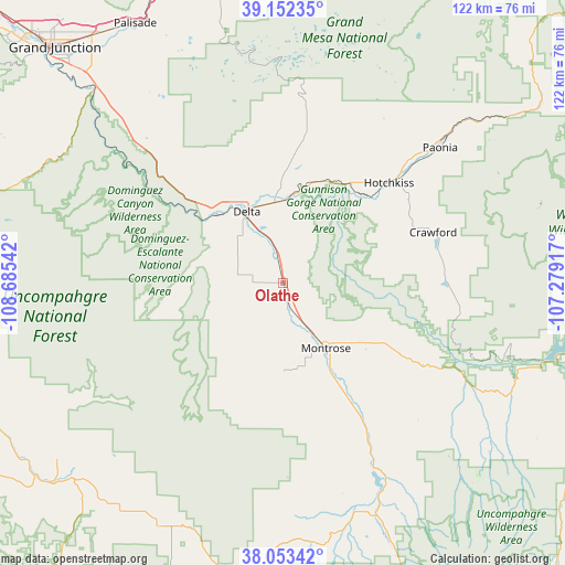
Olathe GPS coordinates[2]
38° 36' 17.964" North, 107° 58' 56.244" West
| Map corner | latitude | longitude |
|---|---|---|
| Upper-left | 39.15235°, | -108.68542° |
| Center: | 38.60499°, | -107.98229° |
| Lower-right: | 38.05342°, | -107.27917° |
| Map W x H: | 122.2×122.2 km | = 75.9×75.9mi |
| max Lat: | 71.29058° ⇑58.1% North |
| Olathe: | 38.60499° |
| min Lat: | ⇓41.9% South 19.06759° |
| min Long | Olathe | max Long |
| -171.73463° | -107.98229° | -66.98998° |
| W 15%⇐ | ⇒85% E |
Elevation
Elevation of Olathe is 1636 m = 5367 ft, and this is 1341.2 m = 4400 ft above average elevation for this country.
| Max E: |
3189 m = 10463 ft | 2.4% |
| Olathe | 1636 m 5367 ft | |
| Avg. | 294.8 m = 967 ft | |
Min E: |
-60 m = -197 ft | 97.6% |
See also: United States elevation on elevation.city.
Geographical zone
Olathe is located in North temperate zone (between Tropic of Cancer and the Arctic Circle). Distance of this Northern Tropic circle is 1686.6 km =1048 mi to South.| Distance of | km | miles | from Olathe |
|---|---|---|---|
| North Pole | 5714.6 | 3550.9 | to North |
| Arctic Circle | 3108.7 | 1931.7 | to North |
| Tropic Cancer | 1686.6 | 1048 | to South |
| Equator | 4292.5 | 2667.2 | to South |


Nearby cities:
15 places around Olathe: (largest is in red/bold)
• Cedaredge
33.3 km =20.7 mi,  8°
8°
• Clifton
67.6 km =42 mi,  323°
323°
• Delta
17 km =10.6 mi,  333°
333°
• Fruitvale
69.2 km =43 mi, 319°
• Hotchkiss
31.4 km =19.5 mi,  46°
46°
• Loghill Village
48.9 km =30.4 mi,  158°
158°
• Montrose
16.8 km =10.4 mi,  146°
146°
• Naturita
66.8 km =41.5 mi,  229°
229°
• Norwood
59.3 km =36.8 mi,  207°
207°
• Nucla
61.8 km =38.4 mi, 232°
• Orchard City
24.9 km =15.5 mi,  2°
2°
• Orchard Mesa
69.4 km =43.1 mi,  314°
314°
• Palisade
64.6 km =40.1 mi, 330°
• Paonia
44.8 km =27.8 mi, 49°
• Ridgway
53.8 km =33.4 mi, 159°
Sources, notices
• [Note1] Compared only with cities in United States existing in our database
• [Src1] Map data: © OpenStreetMap contributors (CC-BY-SA)
• [Src2] Other city data from geonames.org with taken over terms of usage.
• [Src3] Geographical zone / Annual Mean Temperature by Robert A. Rohde @ Wikipedia
