Loghill Village geodata
Loghill Village (Colorado) is a populated place; located in United States in America/Denver (GMT-6) time zone. With population of 521 people, there are 20618 cities with bigger population in this country. Compared to other cities in United States, 60.7% of cities are located further ↑North; 84.9% of cities are located further →East and 99.8% of cities have lower elevation than Loghill Village. Note1


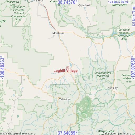
Loghill Village GPS coordinates[2]
38° 11' 42.972" North, 107° 46' 46.2" West
| Map corner | latitude | longitude |
|---|---|---|
| Upper-left | 38.74576°, | -108.48263° |
| Center: | 38.19527°, | -107.7795° |
| Lower-right: | 37.64059°, | -107.07638° |
| Map W x H: | 122.9×122.9 km | = 76.4×76.4mi |
| max Lat: | 71.29058° ⇑60.7% North |
| Loghill Village: | 38.19527° |
| min Lat: | ⇓39.3% South 19.06759° |
| min Long | Loghill Village | max Long |
| -171.73463° | -107.7795° | -66.98998° |
| W 15.1%⇐ | ⇒84.9% E |
Elevation
Elevation of Loghill Village is 2408 m = 7900 ft, and this is 2113.2 m = 6933 ft above average elevation for this country.
| Max E: |
3189 m = 10463 ft | 0.2% |
| Loghill Village | 2408 m 7900 ft | |
| Avg. | 294.8 m = 967 ft | |
Min E: |
-60 m = -197 ft | 99.8% |
See also: United States elevation on elevation.city.
Geographical zone
Loghill Village is located in North temperate zone (between Tropic of Cancer and the Arctic Circle). Distance of this Northern Tropic circle is 1641 km =1019.7 mi to South.| Distance of | km | miles | from Loghill Village |
|---|---|---|---|
| North Pole | 5760.1 | 3579.2 | to North |
| Arctic Circle | 3154.3 | 1960 | to North |
| Tropic Cancer | 1641 | 1019.7 | to South |
| Equator | 4246.9 | 2638.9 | to South |


Nearby cities:
15 places around Loghill Village: (largest is in red/bold)
• Delta
65.8 km =40.9 mi,  337°
337°
• Hotchkiss
67.4 km =41.9 mi,  4°
4°
• Lake City
44.6 km =27.7 mi,  114°
114°
• Montrose
32.6 km =20.3 mi,  345°
345°
• Mountain Village
30.1 km =18.7 mi,  192°
192°
• Naturita
69 km =42.9 mi,  272°
272°
• Norwood
45.4 km =28.2 mi,  260°
260°
• Nucla
67.6 km =42 mi,  277°
277°
• Olathe
48.9 km =30.4 mi, 338°
• Orchard City
72.3 km =44.9 mi, 346°
• Ouray
21.4 km =13.3 mi,  153°
153°
• Paonia
76.6 km =47.6 mi,  12°
12°
• Ridgway
5 km =3.1 mi,  161°
161°
• Silverton
43.8 km =27.2 mi,  166°
166°
• Telluride
28.8 km =17.9 mi, 185°
Sources, notices
• [Note1] Compared only with cities in United States existing in our database
• [Src1] Map data: © OpenStreetMap contributors (CC-BY-SA)
• [Src2] Other city data from geonames.org with taken over terms of usage.
• [Src3] Geographical zone / Annual Mean Temperature by Robert A. Rohde @ Wikipedia
