Montrose geodata
Montrose (Colorado) is a seat of a second-order administrative division; located in United States in America/Denver (GMT-6) time zone. With population of 19,062 people, there are 2646 cities with bigger population in this country. Compared to other cities in United States, 58.9% of cities are located further ↑North; 84.9% of cities are located further →East and 98.3% of cities have lower elevation than Montrose. Note1


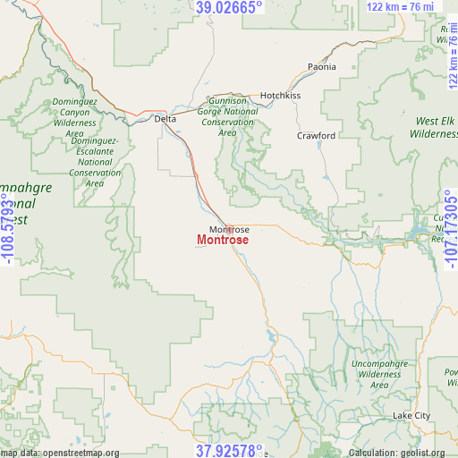
Montrose GPS coordinates[2]
38° 28' 41.952" North, 107° 52' 34.212" West
| Map corner | latitude | longitude |
|---|---|---|
| Upper-left | 39.02665°, | -108.5793° |
| Center: | 38.47832°, | -107.87617° |
| Lower-right: | 37.92578°, | -107.17305° |
| Map W x H: | 122.4×122.4 km | = 76.1×76.1mi |
| max Lat: | 71.29058° ⇑58.9% North |
| Montrose: | 38.47832° |
| min Lat: | ⇓41.1% South 19.06759° |
| min Long | Montrose | max Long |
| -171.73463° | -107.87617° | -66.98998° |
| W 15.1%⇐ | ⇒84.9% E |
Elevation
Elevation of Montrose is 1776 m = 5827 ft, and this is 1481.2 m = 4860 ft above average elevation for this country.
| Max E: |
3189 m = 10463 ft | 1.7% |
| Montrose | 1776 m 5827 ft | |
| Avg. | 294.8 m = 967 ft | |
Min E: |
-60 m = -197 ft | 98.3% |
See also: United States elevation on elevation.city.
Geographical zone
Montrose is located in North temperate zone (between Tropic of Cancer and the Arctic Circle). Distance of this Northern Tropic circle is 1672.5 km =1039.2 mi to South.| Distance of | km | miles | from Montrose |
|---|---|---|---|
| North Pole | 5728.7 | 3559.6 | to North |
| Arctic Circle | 3122.8 | 1940.4 | to North |
| Tropic Cancer | 1672.5 | 1039.2 | to South |
| Equator | 4278.4 | 2658.5 | to South |


Nearby cities:
15 places around Montrose: (largest is in red/bold)
• Cedaredge
47.3 km =29.4 mi,  354°
354°
• Delta
33.8 km =21 mi,  330°
330°
• Hotchkiss
38.2 km =23.7 mi,  20°
20°
• Lake City
69.9 km =43.4 mi,  135°
135°
• Loghill Village
32.6 km =20.3 mi,  165°
165°
• Mountain Village
60.8 km =37.8 mi,  178°
178°
• Naturita
67 km =41.6 mi,  244°
244°
• Norwood
53 km =32.9 mi,  223°
223°
• Nucla
63 km =39.1 mi,  248°
248°
• Olathe
16.8 km =10.4 mi, 326°
• Orchard City
39.8 km =24.7 mi, 348°
• Ouray
53.7 km =33.4 mi,  160°
160°
• Paonia
49.9 km =31 mi,  29°
29°
• Ridgway
37.5 km =23.3 mi, 164°
• Telluride
60.4 km =37.5 mi, 174°
Sources, notices
• [Note1] Compared only with cities in United States existing in our database
• [Src1] Map data: © OpenStreetMap contributors (CC-BY-SA)
• [Src2] Other city data from geonames.org with taken over terms of usage.
• [Src3] Geographical zone / Annual Mean Temperature by Robert A. Rohde @ Wikipedia
