Collbran geodata
Collbran (Colorado) is a populated place; located in United States in America/Denver (GMT-6) time zone. With population of 702 people, there are 18655 cities with bigger population in this country. Compared to other cities in United States, 52.7% of cities are located further ↑North; 85% of cities are located further →East and 98.5% of cities have lower elevation than Collbran. Note1


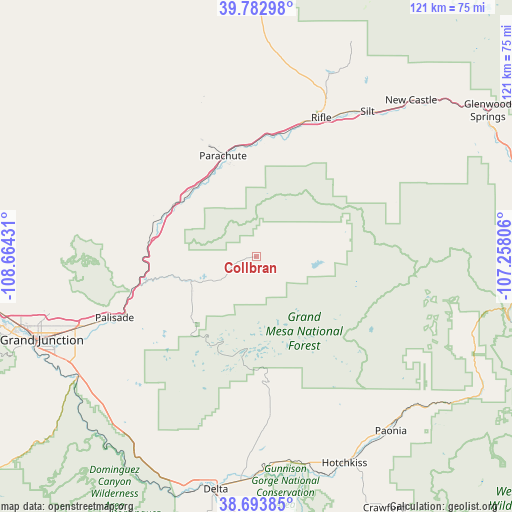
Collbran GPS coordinates[2]
39° 14' 25.908" North, 107° 57' 40.248" West
| Map corner | latitude | longitude |
|---|---|---|
| Upper-left | 39.78298°, | -108.66431° |
| Center: | 39.24053°, | -107.96118° |
| Lower-right: | 38.69385°, | -107.25806° |
| Map W x H: | 121.1×121.1 km | = 75.2×75.2mi |
| max Lat: | 71.29058° ⇑52.7% North |
| Collbran: | 39.24053° |
| min Lat: | ⇓47.3% South 19.06759° |
| min Long | Collbran | max Long |
| -171.73463° | -107.96118° | -66.98998° |
| W 15%⇐ | ⇒85% E |
Elevation
Elevation of Collbran is 1832 m = 6010 ft, and this is 1537.2 m = 5043 ft above average elevation for this country.
| Max E: |
3189 m = 10463 ft | 1.5% |
| Collbran | 1832 m 6010 ft | |
| Avg. | 294.8 m = 967 ft | |
Min E: |
-60 m = -197 ft | 98.5% |
See also: United States elevation on elevation.city.
Geographical zone
Collbran is located in North temperate zone (between Tropic of Cancer and the Arctic Circle). Distance of this Northern Tropic circle is 1757.2 km =1091.9 mi to South.| Distance of | km | miles | from Collbran |
|---|---|---|---|
| North Pole | 5643.9 | 3507 | to North |
| Arctic Circle | 3038 | 1887.7 | to North |
| Tropic Cancer | 1757.2 | 1091.9 | to South |
| Equator | 4363.1 | 2711.1 | to South |


Nearby cities:
15 places around Collbran: (largest is in red/bold)
• Battlement Mesa
23 km =14.3 mi,  346°
346°
• Cedaredge
37.8 km =23.5 mi,  175°
175°
• Clifton
45.2 km =28.1 mi,  248°
248°
• Delta
56.2 km =34.9 mi,  189°
189°
• Fruitvale
49.4 km =30.7 mi, 249°
• Grand Junction
54.5 km =33.9 mi, 248°
• Hotchkiss
53.3 km =33.1 mi,  156°
156°
• New Castle
51.9 km =32.2 mi,  44°
44°
• Orchard City
45.8 km =28.5 mi, 181°
• Orchard Mesa
55.5 km =34.5 mi, 246°
• Palisade
36.6 km =22.7 mi, 246°
• Paonia
52.2 km =32.4 mi,  142°
142°
• Parachute
24.8 km =15.4 mi,  341°
341°
• Rifle
36.1 km =22.4 mi,  25°
25°
• Silt
43.1 km =26.8 mi, 37°
Sources, notices
• [Note1] Compared only with cities in United States existing in our database
• [Src1] Map data: © OpenStreetMap contributors (CC-BY-SA)
• [Src2] Other city data from geonames.org with taken over terms of usage.
• [Src3] Geographical zone / Annual Mean Temperature by Robert A. Rohde @ Wikipedia
