Palisade geodata
Palisade (Colorado) is a populated place; located in United States in America/Denver (GMT-6) time zone. With population of 2,651 people, there are 10284 cities with bigger population in this country. Compared to other cities in United States, 53.8% of cities are located further ↑North; 85.2% of cities are located further →East and 96.3% of cities have lower elevation than Palisade. Note1


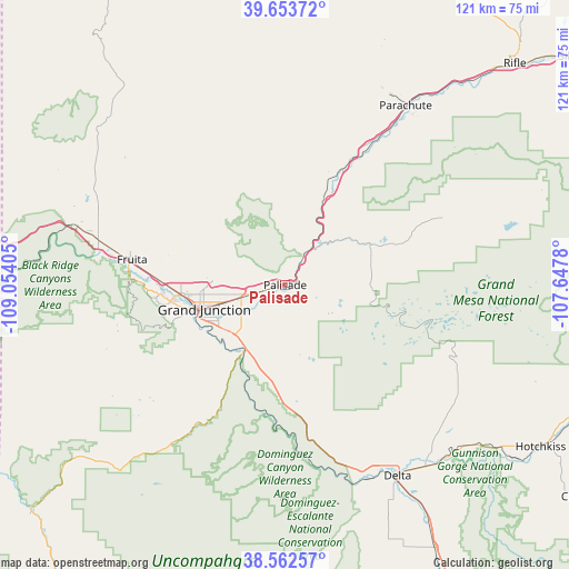
Palisade GPS coordinates[2]
39° 6' 36.936" North, 108° 21' 3.312" West
| Map corner | latitude | longitude |
|---|---|---|
| Upper-left | 39.65372°, | -109.05405° |
| Center: | 39.11026°, | -108.35092° |
| Lower-right: | 38.56257°, | -107.6478° |
| Map W x H: | 121.3×121.3 km | = 75.4×75.4mi |
| max Lat: | 71.29058° ⇑53.8% North |
| Palisade: | 39.11026° |
| min Lat: | ⇓46.2% South 19.06759° |
| min Long | Palisade | max Long |
| -171.73463° | -108.35092° | -66.98998° |
| W 14.8%⇐ | ⇒85.2% E |
Elevation
Elevation of Palisade is 1446 m = 4744 ft, and this is 1151.2 m = 3777 ft above average elevation for this country.
| Max E: |
3189 m = 10463 ft | 3.7% |
| Palisade | 1446 m 4744 ft | |
| Avg. | 294.8 m = 967 ft | |
Min E: |
-60 m = -197 ft | 96.3% |
See also: United States elevation on elevation.city.
Geographical zone
Palisade is located in North temperate zone (between Tropic of Cancer and the Arctic Circle). Distance of this Northern Tropic circle is 1742.7 km =1082.9 mi to South.| Distance of | km | miles | from Palisade |
|---|---|---|---|
| North Pole | 5658.4 | 3516 | to North |
| Arctic Circle | 3052.5 | 1896.7 | to North |
| Tropic Cancer | 1742.7 | 1082.9 | to South |
| Equator | 4348.7 | 2702.2 | to South |


Nearby cities:
15 places around Palisade: (largest is in red/bold)
• Battlement Mesa
46.3 km =28.8 mi,  37°
37°
• Cedaredge
43.4 km =27 mi,  122°
122°
• Clifton
8.7 km =5.4 mi,  256°
256°
• Collbran
36.6 km =22.7 mi,  66°
66°
• Delta
47.6 km =29.6 mi,  149°
149°
• Fruita
33.1 km =20.6 mi,  279°
279°
• Fruitvale
13 km =8.1 mi, 255°
• Grand Junction
18 km =11.2 mi,  253°
253°
• Hotchkiss
64.6 km =40.1 mi, 122°
• Loma
41 km =25.5 mi, 283°
• Olathe
64.6 km =40.1 mi, 150°
• Orchard City
45.4 km =28.2 mi,  133°
133°
• Orchard Mesa
18.9 km =11.7 mi, 246°
• Parachute
45.8 km =28.5 mi,  34°
34°
• Redlands
24.8 km =15.4 mi, 261°
Sources, notices
• [Note1] Compared only with cities in United States existing in our database
• [Src1] Map data: © OpenStreetMap contributors (CC-BY-SA)
• [Src2] Other city data from geonames.org with taken over terms of usage.
• [Src3] Geographical zone / Annual Mean Temperature by Robert A. Rohde @ Wikipedia
