Southglenn geodata
Southglenn (Colorado) is a section of populated place; located in United States in America/Denver (GMT-6) time zone. With population of 42,268 people, there are 1132 cities with bigger population in this country. Compared to other cities in United States, 50.2% of cities are located further ↑North; 83.2% of cities are located further →East and 98% of cities have lower elevation than Southglenn. Note1


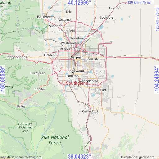
Southglenn GPS coordinates[2]
39° 35' 13.956" North, 104° 57' 9.936" West
| Map corner | latitude | longitude |
|---|---|---|
| Upper-left | 40.12696°, | -105.65589° |
| Center: | 39.58721°, | -104.95276° |
| Lower-right: | 39.04323°, | -104.24964° |
| Map W x H: | 120.5×120.5 km | = 74.9×74.9mi |
| max Lat: | 71.29058° ⇑50.2% North |
| Southglenn: | 39.58721° |
| min Lat: | ⇓49.8% South 19.06759° |
| min Long | Southglenn | max Long |
| -171.73463° | -104.95276° | -66.98998° |
| W 16.8%⇐ | ⇒83.2% E |
Elevation
Elevation of Southglenn is 1710 m = 5610 ft, and this is 1415.2 m = 4643 ft above average elevation for this country.
| Max E: |
3189 m = 10463 ft | 2% |
| Southglenn | 1710 m 5610 ft | |
| Avg. | 294.8 m = 967 ft | |
Min E: |
-60 m = -197 ft | 98% |
See also: Southglenn elevation on elevation.city.
Geographical zone
Southglenn is located in North temperate zone (between Tropic of Cancer and the Arctic Circle). Distance of this Northern Tropic circle is 1795.8 km =1115.9 mi to South.| Distance of | km | miles | from Southglenn |
|---|---|---|---|
| North Pole | 5605.4 | 3483 | to North |
| Arctic Circle | 2999.5 | 1863.8 | to North |
| Tropic Cancer | 1795.8 | 1115.9 | to South |
| Equator | 4401.7 | 2735.1 | to South |


Nearby cities:
15 places around Southglenn: (largest is in red/bold)
• Acres Green
5.9 km =3.7 mi,  124°
124°
• Carriage Club
7.5 km =4.7 mi,  143°
143°
• Castlewood
4.4 km =2.7 mi,  93°
93°
• Centennial
6.6 km =4.1 mi,  97°
97°
• Cherry Creek
8 km =5 mi,  48°
48°
• Cherry Hills Village
6.1 km =3.8 mi,  354°
354°
• Columbine Valley
7 km =4.3 mi,  282°
282°
• Englewood
7.4 km =4.6 mi,  336°
336°
• Greenwood Village
3.3 km =2.1 mi,  2°
2°
• Heritage Hills
8 km =5 mi,  127°
127°
• Highlands Ranch
4 km =2.5 mi,  201°
201°
• Inverness
7.9 km =4.9 mi, 97°
• Littleton
6.2 km =3.9 mi,  297°
297°
• Lone Tree
6.9 km =4.3 mi, 124°
• Sheridan
9.1 km =5.7 mi,  316°
316°
Sources, notices
• [Note1] Compared only with cities in United States existing in our database
• [Src1] Map data: © OpenStreetMap contributors (CC-BY-SA)
• [Src2] Other city data from geonames.org with taken over terms of usage.
• [Src3] Geographical zone / Annual Mean Temperature by Robert A. Rohde @ Wikipedia
