Littleton geodata
Littleton (Colorado) is a seat of a second-order administrative division; located in United States in America/Denver (GMT-6) time zone. With population of 46,368 people, there are 1037 cities with bigger population in this country. Compared to other cities in United States, 50% of cities are located further ↓South; 83.3% of cities are located further →East and 97.6% of cities have lower elevation than Littleton. Note1


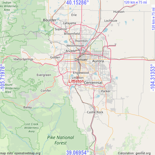
Littleton GPS coordinates[2]
39° 36' 47.952" North, 105° 0' 59.94" West
| Map corner | latitude | longitude |
|---|---|---|
| Upper-left | 40.15286°, | -105.71978° |
| Center: | 39.61332°, | -105.01665° |
| Lower-right: | 39.06954°, | -104.31353° |
| Map W x H: | 120.5×120.5 km | = 74.9×74.9mi |
| max Lat: | 71.29058° ⇑50% North |
| Littleton: | 39.61332° |
| min Lat: | ⇓50% South 19.06759° |
| min Long | Littleton | max Long |
| -171.73463° | -105.01665° | -66.98998° |
| W 16.7%⇐ | ⇒83.3% E |
Elevation
Elevation of Littleton is 1635 m = 5364 ft, and this is 1340.2 m = 4397 ft above average elevation for this country.
| Max E: |
3189 m = 10463 ft | 2.4% |
| Littleton | 1635 m 5364 ft | |
| Avg. | 294.8 m = 967 ft | |
Min E: |
-60 m = -197 ft | 97.6% |
See also: Littleton elevation on elevation.city.
Geographical zone
Littleton is located in North temperate zone (between Tropic of Cancer and the Arctic Circle). Distance of this Northern Tropic circle is 1798.7 km =1117.7 mi to South.| Distance of | km | miles | from Littleton |
|---|---|---|---|
| North Pole | 5602.5 | 3481.2 | to North |
| Arctic Circle | 2996.6 | 1862 | to North |
| Tropic Cancer | 1798.7 | 1117.7 | to South |
| Equator | 4404.6 | 2736.9 | to South |


Nearby cities:
15 places around Littleton: (largest is in red/bold)
• Acres Green
12.1 km =7.5 mi,  121°
121°
• Bow Mar
3.3 km =2.1 mi,  300°
300°
• Castlewood
10.4 km =6.5 mi,  107°
107°
• Cherry Creek
11.7 km =7.3 mi,  78°
78°
• Cherry Hills Village
5.8 km =3.6 mi,  57°
57°
• Columbine
5.3 km =3.3 mi,  237°
237°
• Columbine Valley
1.9 km =1.2 mi,  224°
224°
• Englewood
4.6 km =2.9 mi,  32°
32°
• Greenwood Village
5.7 km =3.5 mi,  85°
85°
• Highlands Ranch
7.7 km =4.8 mi,  148°
148°
• Holly Hills
10.4 km =6.5 mi,  54°
54°
• Ken Caryl
9.2 km =5.7 mi, 243°
• Lakewood
11.6 km =7.2 mi,  331°
331°
• Sheridan
3.8 km =2.4 mi,  348°
348°
• Southglenn
6.2 km =3.9 mi, 117°
Sources, notices
• [Note1] Compared only with cities in United States existing in our database
• [Src1] Map data: © OpenStreetMap contributors (CC-BY-SA)
• [Src2] Other city data from geonames.org with taken over terms of usage.
• [Src3] Geographical zone / Annual Mean Temperature by Robert A. Rohde @ Wikipedia
