White Sands geodata
White Sands (New Mexico) is a populated place; located in United States in America/Denver (GMT-6) time zone. With population of 1,651 people, there are 13082 cities with bigger population in this country. Compared to other cities in United States, 87.6% of cities are located further ↑North; 84.3% of cities are located further →East and 95.1% of cities have lower elevation than White Sands. Note1


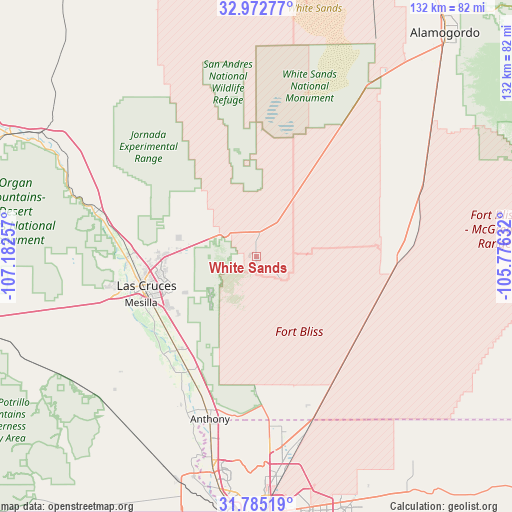
White Sands GPS coordinates[2]
32° 22' 51.348" North, 106° 28' 45.984" West
| Map corner | latitude | longitude |
|---|---|---|
| Upper-left | 32.97277°, | -107.18257° |
| Center: | 32.38093°, | -106.47944° |
| Lower-right: | 31.78519°, | -105.77632° |
| Map W x H: | 132×132 km | = 82×82mi |
| max Lat: | 71.29058° ⇑87.6% North |
| White Sands: | 32.38093° |
| min Lat: | ⇓12.4% South 19.06759° |
| min Long | White Sands | max Long |
| -171.73463° | -106.47944° | -66.98998° |
| W 15.7%⇐ | ⇒84.3% E |
Elevation
Elevation of White Sands is 1294 m = 4245 ft, and this is 999.2 m = 3278 ft above average elevation for this country.
| Max E: |
3189 m = 10463 ft | 4.9% |
| White Sands | 1294 m 4245 ft | |
| Avg. | 294.8 m = 967 ft | |
Min E: |
-60 m = -197 ft | 95.1% |
See also: United States elevation on elevation.city.
Geographical zone
White Sands is located in North temperate zone (between Tropic of Cancer and the Arctic Circle). Distance of this Northern Tropic circle is 994.5 km =618 mi to South.| Distance of | km | miles | from White Sands |
|---|---|---|---|
| North Pole | 6406.6 | 3980.9 | to North |
| Arctic Circle | 3800.8 | 2361.7 | to North |
| Tropic Cancer | 994.5 | 618 | to South |
| Equator | 3600.4 | 2237.2 | to South |


Nearby cities:
15 places around White Sands: (largest is in red/bold)
• Anthony
43.6 km =27.1 mi,  195°
195°
• Berino
37 km =23 mi, 201°
• Chamberino
42.6 km =26.5 mi,  207°
207°
• Chaparral
40.7 km =25.3 mi,  167°
167°
• Doña Ana
31.4 km =19.5 mi,  271°
271°
• Fairacres
35.5 km =22.1 mi,  256°
256°
• La Mesa
35.9 km =22.3 mi,  216°
216°
• Las Cruces
29.1 km =18.1 mi,  254°
254°
• Mesilla
32.6 km =20.3 mi, 247°
• Mesquite
31.6 km =19.6 mi, 220°
• San Miguel
34.7 km =21.6 mi, 223°
• San Pablo
31.2 km =19.4 mi,  242°
242°
• San Ysidro
31.3 km =19.4 mi, 263°
• University Park
27.9 km =17.3 mi, 247°
• Vado
34.5 km =21.4 mi, 209°
Sources, notices
• [Note1] Compared only with cities in United States existing in our database
• [Src1] Map data: © OpenStreetMap contributors (CC-BY-SA)
• [Src2] Other city data from geonames.org with taken over terms of usage.
• [Src3] Geographical zone / Annual Mean Temperature by Robert A. Rohde @ Wikipedia
