Las Vegas geodata
Las Vegas (New Mexico) is a seat of a second-order administrative division; located in United States in America/Denver (GMT-6) time zone. With population of 13,386 people, there are 3578 cities with bigger population in this country. Compared to other cities in United States, 72.2% of cities are located further ↑North; 83.5% of cities are located further →East and 99% of cities have lower elevation than Las Vegas. Note1


Las Vegas GPS coordinates[2]
35° 35' 38.148" North, 105° 13' 26.04" West
| Map corner | latitude | longitude |
|---|---|---|
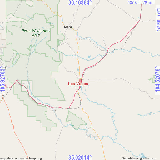
| Upper-left | 36.16364°, | -105.92703° |
| Center: | 35.59393°, | -105.2239° |
| Lower-right: | 35.02014°, | -104.52078° |
| Map W x H: | 127.1×127.1 km | = 79×79mi |
| max Lat: | 71.29058° ⇑72.2% North |
| Las Vegas: | 35.59393° |
| min Lat: | ⇓27.8% South 19.06759° |
| min Long | Las Vegas | max Long |
| -171.73463° | -105.2239° | -66.98998° |
| W 16.5%⇐ | ⇒83.5% E |
Elevation
Elevation of Las Vegas is 1960 m = 6430 ft, and this is 1665.2 m = 5463 ft above average elevation for this country.
| Max E: |
3189 m = 10463 ft | 1% |
| Las Vegas | 1960 m 6430 ft | |
| Avg. | 294.8 m = 967 ft | |
Min E: |
-60 m = -197 ft | 99% |
See also: United States elevation on elevation.city.
Geographical zone
Las Vegas is located in North temperate zone (between Tropic of Cancer and the Arctic Circle). Distance of this Northern Tropic circle is 1351.8 km =840 mi to South.| Distance of | km | miles | from Las Vegas |
|---|---|---|---|
| North Pole | 6049.4 | 3758.9 | to North |
| Arctic Circle | 3443.5 | 2139.7 | to North |
| Tropic Cancer | 1351.8 | 840 | to South |
| Equator | 3957.7 | 2459.2 | to South |


Nearby cities:
15 places around Las Vegas: (largest is in red/bold)
• Agua Fria
72.5 km =45 mi,  275°
275°
• Chimayo
79.6 km =49.5 mi,  304°
304°
• East Pecos
39.9 km =24.8 mi,  266°
266°
• El Valle de Arroyo Seco
83.4 km =51.8 mi, 299°
• Eldorado at Santa Fe
64.7 km =40.2 mi,  263°
263°
• La Cienega
82.1 km =51 mi, 267°
• La Puebla
82.4 km =51.2 mi, 302°
• Mora
43.4 km =27 mi,  347°
347°
• Nambe
76.1 km =47.3 mi, 295°
• Pecos
40.9 km =25.4 mi, 266°
• Peñasco
76.4 km =47.5 mi,  326°
326°
• Pojoaque
79.4 km =49.3 mi,  294°
294°
• Santa Fe
65.3 km =40.6 mi, 279°
• Tesuque
66.7 km =41.4 mi, 286°
• Truchas
72.9 km =45.3 mi,  313°
313°
Sources, notices
• [Note1] Compared only with cities in United States existing in our database
• [Src1] Map data: © OpenStreetMap contributors (CC-BY-SA)
• [Src2] Other city data from geonames.org with taken over terms of usage.
• [Src3] Geographical zone / Annual Mean Temperature by Robert A. Rohde @ Wikipedia
