Pecos geodata
Pecos (New Mexico) is a populated place; located in United States in America/Denver (GMT-6) time zone. With population of 1,324 people, there are 14466 cities with bigger population in this country. Compared to other cities in United States, 72.3% of cities are located further ↑North; 83.7% of cities are located further →East and 99.4% of cities have lower elevation than Pecos. Note1


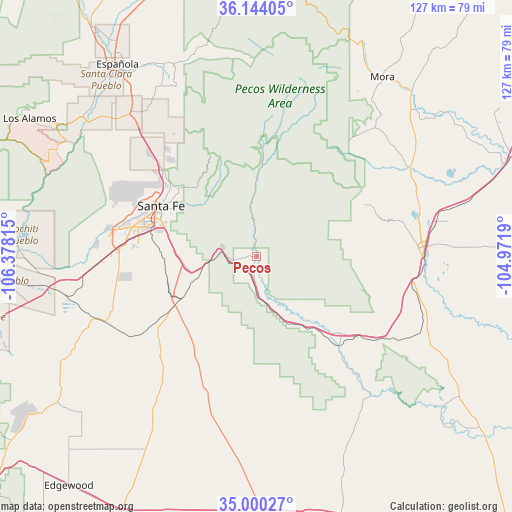
Pecos GPS coordinates[2]
35° 34' 27.12" North, 105° 40' 30.072" West
| Map corner | latitude | longitude |
|---|---|---|
| Upper-left | 36.14405°, | -106.37815° |
| Center: | 35.5742°, | -105.67502° |
| Lower-right: | 35.00027°, | -104.9719° |
| Map W x H: | 127.2×127.2 km | = 79×79mi |
| max Lat: | 71.29058° ⇑72.3% North |
| Pecos: | 35.5742° |
| min Lat: | ⇓27.7% South 19.06759° |
| min Long | Pecos | max Long |
| -171.73463° | -105.67502° | -66.98998° |
| W 16.3%⇐ | ⇒83.7% E |
Elevation
Elevation of Pecos is 2110 m = 6923 ft, and this is 1815.2 m = 5955 ft above average elevation for this country.
| Max E: |
3189 m = 10463 ft | 0.59999999999999% |
| Pecos | 2110 m 6923 ft | |
| Avg. | 294.8 m = 967 ft | |
Min E: |
-60 m = -197 ft | 99.4% |
See also: United States elevation on elevation.city.
Geographical zone
Pecos is located in North temperate zone (between Tropic of Cancer and the Arctic Circle). Distance of this Northern Tropic circle is 1349.6 km =838.6 mi to South.| Distance of | km | miles | from Pecos |
|---|---|---|---|
| North Pole | 6051.6 | 3760.3 | to North |
| Arctic Circle | 3445.7 | 2141.1 | to North |
| Tropic Cancer | 1349.6 | 838.6 | to South |
| Equator | 3955.5 | 2457.8 | to South |


Nearby cities:
15 places around Pecos: (largest is in red/bold)
• Agua Fria
32.6 km =20.3 mi,  285°
285°
• Chimayo
53.7 km =33.4 mi,  332°
332°
• East Pecos
1 km =0.6 mi,  93°
93°
• El Rancho
50.6 km =31.4 mi,  313°
313°
• El Valle de Arroyo Seco
53.8 km =33.4 mi,  323°
323°
• Eldorado at Santa Fe
24.1 km =15 mi,  257°
257°
• La Cienega
41.2 km =25.6 mi,  268°
268°
• Las Vegas
40.9 km =25.4 mi, 86°
• Mora
54.3 km =33.7 mi,  34°
34°
• Nambe
45.1 km =28 mi, 321°
• Pojoaque
47.3 km =29.4 mi, 318°
• San Ildefonso Pueblo
53.4 km =33.2 mi, 311°
• Santa Fe
26.9 km =16.7 mi,  297°
297°
• Tesuque
31.2 km =19.4 mi, 311°
• Truchas
53.6 km =33.3 mi,  346°
346°
Sources, notices
• [Note1] Compared only with cities in United States existing in our database
• [Src1] Map data: © OpenStreetMap contributors (CC-BY-SA)
• [Src2] Other city data from geonames.org with taken over terms of usage.
• [Src3] Geographical zone / Annual Mean Temperature by Robert A. Rohde @ Wikipedia
