Roswell geodata
Roswell (New Mexico) is a seat of a second-order administrative division; located in United States in America/Denver (GMT-6) time zone. With population of 48,544 people, there are 989 cities with bigger population in this country. Compared to other cities in United States, 83.6% of cities are located further ↑North; 82.8% of cities are located further →East and 94% of cities have lower elevation than Roswell. Note1


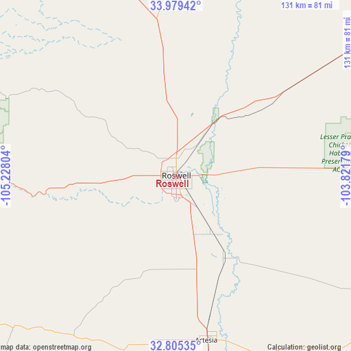
Roswell GPS coordinates[2]
33° 23' 39.732" North, 104° 31' 29.676" West
| Map corner | latitude | longitude |
|---|---|---|
| Upper-left | 33.97942°, | -105.22804° |
| Center: | 33.39437°, | -104.52491° |
| Lower-right: | 32.80535°, | -103.82179° |
| Map W x H: | 130.5×130.5 km | = 81.1×81.1mi |
| max Lat: | 71.29058° ⇑83.6% North |
| Roswell: | 33.39437° |
| min Lat: | ⇓16.4% South 19.06759° |
| min Long | Roswell | max Long |
| -171.73463° | -104.52491° | -66.98998° |
| W 17.2%⇐ | ⇒82.8% E |
Elevation
Elevation of Roswell is 1093 m = 3586 ft, and this is 798.2 m = 2619 ft above average elevation for this country.
| Max E: |
3189 m = 10463 ft | 6% |
| Roswell | 1093 m 3586 ft | |
| Avg. | 294.8 m = 967 ft | |
Min E: |
-60 m = -197 ft | 94% |
See also: Roswell elevation on elevation.city.
Geographical zone
Roswell is located in North temperate zone (between Tropic of Cancer and the Arctic Circle). Distance of this Northern Tropic circle is 1107.2 km =688 mi to South.| Distance of | km | miles | from Roswell |
|---|---|---|---|
| North Pole | 6294 | 3910.9 | to North |
| Arctic Circle | 3688.1 | 2291.7 | to North |
| Tropic Cancer | 1107.2 | 688 | to South |
| Equator | 3713.1 | 2307.2 | to South |


Nearby cities:
15 places around Roswell: (largest is in red/bold)
• Artesia
62.4 km =38.8 mi,  169°
169°
• Atoka
70.6 km =43.9 mi, 169°
• Capitan
98.6 km =61.3 mi,  279°
279°
• Carlsbad
111.7 km =69.4 mi, 165°
• Dexter
26.1 km =16.2 mi,  147°
147°
• Fort Sumner
122.5 km =76.1 mi,  12°
12°
• Hagerman
36.1 km =22.4 mi, 149°
• La Huerta
109.5 km =68 mi,  164°
164°
• Livingston Wheeler
115.6 km =71.8 mi, 164°
• Lovington
120.4 km =74.8 mi,  114°
114°
• Mescalero
119.1 km =74 mi,  257°
257°
• Midway
13 km =8.1 mi, 148°
• Ruidoso
106.8 km =66.4 mi,  266°
266°
• Ruidoso Downs
100.5 km =62.4 mi, 265°
• Tatum
113.2 km =70.3 mi,  97°
97°
Sources, notices
• [Note1] Compared only with cities in United States existing in our database
• [Src1] Map data: © OpenStreetMap contributors (CC-BY-SA)
• [Src2] Other city data from geonames.org with taken over terms of usage.
• [Src3] Geographical zone / Annual Mean Temperature by Robert A. Rohde @ Wikipedia
