Artesia geodata
Artesia (New Mexico) is a populated place; located in United States in America/Denver (GMT-6) time zone. With population of 12,036 people, there are 3887 cities with bigger population in this country. Compared to other cities in United States, 85.8% of cities are located further ↑North; 82.8% of cities are located further →East and 93.7% of cities have lower elevation than Artesia. Note1


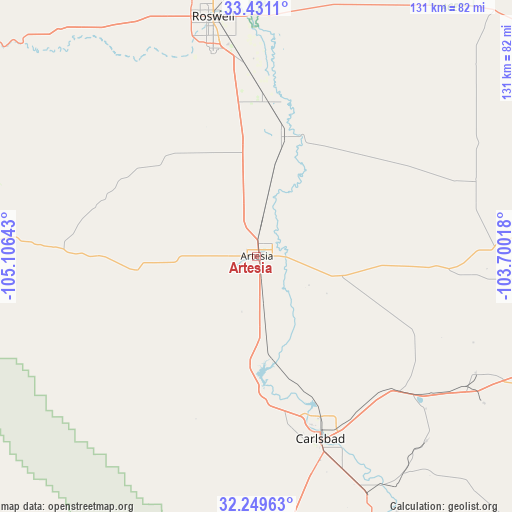
Artesia GPS coordinates[2]
32° 50' 32.388" North, 104° 24' 11.88" West
| Map corner | latitude | longitude |
|---|---|---|
| Upper-left | 33.4311°, | -105.10643° |
| Center: | 32.84233°, | -104.4033° |
| Lower-right: | 32.24963°, | -103.70018° |
| Map W x H: | 131.4×131.4 km | = 81.6×81.6mi |
| max Lat: | 71.29058° ⇑85.8% North |
| Artesia: | 32.84233° |
| min Lat: | ⇓14.2% South 19.06759° |
| min Long | Artesia | max Long |
| -171.73463° | -104.4033° | -66.98998° |
| W 17.2%⇐ | ⇒82.8% E |
Elevation
Elevation of Artesia is 1036 m = 3399 ft, and this is 741.2 m = 2432 ft above average elevation for this country.
| Max E: |
3189 m = 10463 ft | 6.3% |
| Artesia | 1036 m 3399 ft | |
| Avg. | 294.8 m = 967 ft | |
Min E: |
-60 m = -197 ft | 93.7% |
See also: United States elevation on elevation.city.
Geographical zone
Artesia is located in North temperate zone (between Tropic of Cancer and the Arctic Circle). Distance of this Northern Tropic circle is 1045.8 km =649.8 mi to South.| Distance of | km | miles | from Artesia |
|---|---|---|---|
| North Pole | 6355.3 | 3949 | to North |
| Arctic Circle | 3749.4 | 2329.8 | to North |
| Tropic Cancer | 1045.8 | 649.8 | to South |
| Equator | 3651.7 | 2269.1 | to South |


Nearby cities:
15 places around Artesia: (largest is in red/bold)
• Atoka
8.2 km =5.1 mi,  170°
170°
• Carlsbad
49.6 km =30.8 mi,  160°
160°
• Cloudcroft
125.7 km =78.1 mi,  275°
275°
• Dexter
39.6 km =24.6 mi,  4°
4°
• Eunice
124.9 km =77.6 mi,  111°
111°
• Hagerman
31.2 km =19.4 mi,  13°
13°
• Hobbs
119.5 km =74.3 mi,  97°
97°
• La Huerta
47.6 km =29.6 mi, 158°
• Livingston Wheeler
53.6 km =33.3 mi, 159°
• Loving
68.2 km =42.4 mi, 155°
• Lovington
99.1 km =61.6 mi,  83°
83°
• Midway
50.5 km =31.4 mi,  355°
355°
• Roswell
62.4 km =38.8 mi,  349°
349°
• Ruidoso Downs
124.3 km =77.2 mi,  295°
295°
• Tatum
111.2 km =69.1 mi,  65°
65°
Sources, notices
• [Note1] Compared only with cities in United States existing in our database
• [Src1] Map data: © OpenStreetMap contributors (CC-BY-SA)
• [Src2] Other city data from geonames.org with taken over terms of usage.
• [Src3] Geographical zone / Annual Mean Temperature by Robert A. Rohde @ Wikipedia
