Lemmon Valley geodata
Lemmon Valley (Nevada) is a populated place; located in United States in America/Los_Angeles (GMT-7) time zone. With population of 5,040 people, there are 7132 cities with bigger population in this country. Compared to other cities in United States, 50.2% of cities are located further ↓South; 92.7% of cities are located further →East and 96.7% of cities have lower elevation than Lemmon Valley. Note1


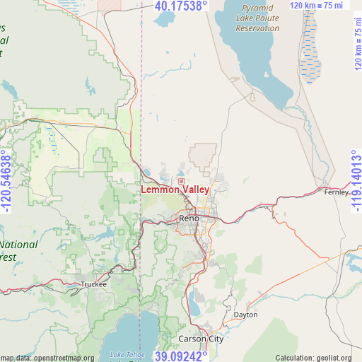
Lemmon Valley GPS coordinates[2]
39° 38' 9.672" North, 119° 50' 35.7" West
| Map corner | latitude | longitude |
|---|---|---|
| Upper-left | 40.17538°, | -120.54638° |
| Center: | 39.63602°, | -119.84325° |
| Lower-right: | 39.09242°, | -119.14013° |
| Map W x H: | 120.4×120.4 km | = 74.8×74.8mi |
| max Lat: | 71.29058° ⇑49.8% North |
| Lemmon Valley: | 39.63602° |
| min Lat: | ⇓50.2% South 19.06759° |
| min Long | Lemmon Valley | max Long |
| -171.73463° | -119.84325° | -66.98998° |
| W 7.3%⇐ | ⇒92.7% E |
Elevation
Elevation of Lemmon Valley is 1511 m = 4957 ft, and this is 1216.2 m = 3990 ft above average elevation for this country.
| Max E: |
3189 m = 10463 ft | 3.3% |
| Lemmon Valley | 1511 m 4957 ft | |
| Avg. | 294.8 m = 967 ft | |
Min E: |
-60 m = -197 ft | 96.7% |
See also: United States elevation on elevation.city.
Geographical zone
Lemmon Valley is located in North temperate zone (between Tropic of Cancer and the Arctic Circle). Distance of this Northern Tropic circle is 1801.2 km =1119.2 mi to South.| Distance of | km | miles | from Lemmon Valley |
|---|---|---|---|
| North Pole | 5599.9 | 3479.6 | to North |
| Arctic Circle | 2994.1 | 1860.4 | to North |
| Tropic Cancer | 1801.2 | 1119.2 | to South |
| Equator | 4407.1 | 2738.4 | to South |


Nearby cities:
15 places around Lemmon Valley: (largest is in red/bold)
• Cold Springs
12.4 km =7.7 mi,  293°
293°
• Golden Valley
2.7 km =1.7 mi,  148°
148°
• Incline Village
44.2 km =27.5 mi,  194°
194°
• Kings Beach
47 km =29.2 mi,  199°
199°
• Loyalton
34.3 km =21.3 mi,  277°
277°
• Mogul
15.3 km =9.5 mi,  207°
207°
• Reno
12.1 km =7.5 mi,  167°
167°
• Spanish Springs
11.7 km =7.3 mi,  82°
82°
• Sparks
13.7 km =8.5 mi, 145°
• Sun Valley
7.3 km =4.5 mi,  127°
127°
• Tahoe Vista
47.5 km =29.5 mi, 202°
• Truckee
45 km =28 mi,  220°
220°
• Verdi
18.1 km =11.2 mi, 223°
• Virginia City
39.9 km =24.8 mi,  155°
155°
• Wadsworth
47.8 km =29.7 mi,  90°
90°
Sources, notices
• [Note1] Compared only with cities in United States existing in our database
• [Src1] Map data: © OpenStreetMap contributors (CC-BY-SA)
• [Src2] Other city data from geonames.org with taken over terms of usage.
• [Src3] Geographical zone / Annual Mean Temperature by Robert A. Rohde @ Wikipedia
