Reno geodata
Reno (Nevada) is a seat of a second-order administrative division; located in United States in America/Los_Angeles (GMT-7) time zone. With population of 241,445 people, there are 96 cities with bigger population in this country. Compared to other cities in United States, 50.7% of cities are located further ↑North; 92.7% of cities are located further →East and 95.8% of cities have lower elevation than Reno. Note1


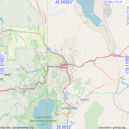
Reno GPS coordinates[2]
39° 31' 46.668" North, 119° 48' 49.68" West
| Map corner | latitude | longitude |
|---|---|---|
| Upper-left | 40.06983°, | -120.51693° |
| Center: | 39.52963°, | -119.8138° |
| Lower-right: | 38.9852°, | -119.11068° |
| Map W x H: | 120.6×120.6 km | = 74.9×74.9mi |
| max Lat: | 71.29058° ⇑50.7% North |
| Reno: | 39.52963° |
| min Lat: | ⇓49.3% South 19.06759° |
| min Long | Reno | max Long |
| -171.73463° | -119.8138° | -66.98998° |
| W 7.3%⇐ | ⇒92.7% E |
Elevation
Elevation of Reno is 1380 m = 4528 ft, and this is 1085.2 m = 3560 ft above average elevation for this country.
| Max E: |
3189 m = 10463 ft | 4.2% |
| Reno | 1380 m 4528 ft | |
| Avg. | 294.8 m = 967 ft | |
Min E: |
-60 m = -197 ft | 95.8% |
See also: Reno elevation on elevation.city.
Geographical zone
Reno is located in North temperate zone (between Tropic of Cancer and the Arctic Circle). Distance of this Northern Tropic circle is 1789.4 km =1111.9 mi to South.| Distance of | km | miles | from Reno |
|---|---|---|---|
| North Pole | 5611.8 | 3487 | to North |
| Arctic Circle | 3005.9 | 1867.8 | to North |
| Tropic Cancer | 1789.4 | 1111.9 | to South |
| Equator | 4395.3 | 2731.1 | to South |


Nearby cities:
15 places around Reno: (largest is in red/bold)
• Cold Springs
21.8 km =13.5 mi,  320°
320°
• Dayton
37.7 km =23.4 mi,  149°
149°
• Golden Valley
9.6 km =6 mi,  353°
353°
• Incline Village
33.8 km =21 mi,  203°
203°
• Kings Beach
37.3 km =23.2 mi,  209°
209°
• Lemmon Valley
12.1 km =7.5 mi, 347°
• Loyalton
40.1 km =24.9 mi,  294°
294°
• Mogul
9.8 km =6.1 mi,  259°
259°
• Spanish Springs
16.1 km =10 mi,  34°
34°
• Sparks
5.3 km =3.3 mi,  83°
83°
• Sun Valley
8.1 km =5 mi,  23°
23°
• Tahoe Vista
38.1 km =23.7 mi, 212°
• Truckee
38.9 km =24.2 mi,  234°
234°
• Verdi
15.1 km =9.4 mi,  265°
265°
• Virginia City
28.2 km =17.5 mi, 150°
Sources, notices
• [Note1] Compared only with cities in United States existing in our database
• [Src1] Map data: © OpenStreetMap contributors (CC-BY-SA)
• [Src2] Other city data from geonames.org with taken over terms of usage.
• [Src3] Geographical zone / Annual Mean Temperature by Robert A. Rohde @ Wikipedia
