Abernathy geodata
Abernathy (Texas) is a populated place; located in United States in America/Chicago (GMT-5) time zone. With population of 2,743 people, there are 10099 cities with bigger population in this country. Compared to other cities in United States, 81.4% of cities are located further ↑North; 81.8% of cities are located further →East and 93.6% of cities have lower elevation than Abernathy. Note1


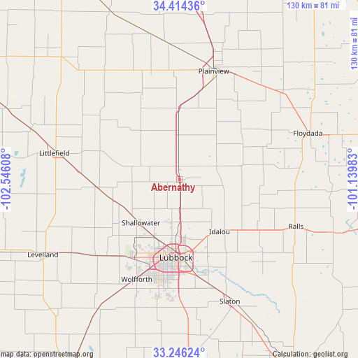
Abernathy GPS coordinates[2]
33° 49' 56.28" North, 101° 50' 34.62" West
| Map corner | latitude | longitude |
|---|---|---|
| Upper-left | 34.41436°, | -102.54608° |
| Center: | 33.8323°, | -101.84295° |
| Lower-right: | 33.24624°, | -101.13983° |
| Map W x H: | 129.9×129.9 km | = 80.7×80.7mi |
| max Lat: | 71.29058° ⇑81.4% North |
| Abernathy: | 33.8323° |
| min Lat: | ⇓18.6% South 19.06759° |
| min Long | Abernathy | max Long |
| -171.73463° | -101.84295° | -66.98998° |
| W 18.2%⇐ | ⇒81.8% E |
Elevation
Elevation of Abernathy is 1026 m = 3366 ft, and this is 731.2 m = 2399 ft above average elevation for this country.
| Max E: |
3189 m = 10463 ft | 6.4% |
| Abernathy | 1026 m 3366 ft | |
| Avg. | 294.8 m = 967 ft | |
Min E: |
-60 m = -197 ft | 93.6% |
See also: United States elevation on elevation.city.
Geographical zone
Abernathy is located in North temperate zone (between Tropic of Cancer and the Arctic Circle). Distance of this Northern Tropic circle is 1155.9 km =718.2 mi to South.| Distance of | km | miles | from Abernathy |
|---|---|---|---|
| North Pole | 6245.3 | 3880.6 | to North |
| Arctic Circle | 3639.4 | 2261.4 | to North |
| Tropic Cancer | 1155.9 | 718.2 | to South |
| Equator | 3761.8 | 2337.5 | to South |


Nearby cities:
15 places around Abernathy: (largest is in red/bold)
• Anton
29.7 km =18.5 mi,  265°
265°
• Hale Center
25.8 km =16 mi,  359°
359°
• Idalou
23.6 km =14.7 mi,  141°
141°
• Littlefield
45.5 km =28.3 mi,  281°
281°
• Lorenzo
33.7 km =20.9 mi,  122°
122°
• Lubbock
28.3 km =17.6 mi,  182°
182°
• New Deal
10.6 km =6.6 mi, 176°
• Olton
47.4 km =29.5 mi,  325°
325°
• Petersburg
23.1 km =14.4 mi,  79°
79°
• Plainview
41.2 km =25.6 mi,  17°
17°
• Ralls
45.6 km =28.3 mi,  112°
112°
• Ransom Canyon
36.5 km =22.7 mi,  155°
155°
• Seth Ward
44.5 km =27.7 mi, 18°
• Shallowater
21.4 km =13.3 mi,  222°
222°
• Wolfforth
39.4 km =24.5 mi,  202°
202°
Sources, notices
• [Note1] Compared only with cities in United States existing in our database
• [Src1] Map data: © OpenStreetMap contributors (CC-BY-SA)
• [Src2] Other city data from geonames.org with taken over terms of usage.
• [Src3] Geographical zone / Annual Mean Temperature by Robert A. Rohde @ Wikipedia
