Lubbock geodata
Lubbock (Texas) is a seat of a second-order administrative division; located in United States in America/Chicago (GMT-5) time zone. With population of 249,042 people, there are 91 cities with bigger population in this country. Compared to other cities in United States, 82.8% of cities are located further ↑North; 81.8% of cities are located further →East and 93.3% of cities have lower elevation than Lubbock. Note1


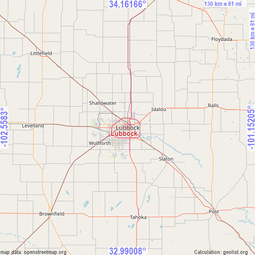
Lubbock GPS coordinates[2]
33° 34' 40.296" North, 101° 51' 18.612" West
| Map corner | latitude | longitude |
|---|---|---|
| Upper-left | 34.16166°, | -102.5583° |
| Center: | 33.57786°, | -101.85517° |
| Lower-right: | 32.99008°, | -101.15205° |
| Map W x H: | 130.3×130.3 km | = 81×81mi |
| max Lat: | 71.29058° ⇑82.8% North |
| Lubbock: | 33.57786° |
| min Lat: | ⇓17.2% South 19.06759° |
| min Long | Lubbock | max Long |
| -171.73463° | -101.85517° | -66.98998° |
| W 18.2%⇐ | ⇒81.8% E |
Elevation
Elevation of Lubbock is 979 m = 3212 ft, and this is 684.2 m = 2245 ft above average elevation for this country.
| Max E: |
3189 m = 10463 ft | 6.7% |
| Lubbock | 979 m 3212 ft | |
| Avg. | 294.8 m = 967 ft | |
Min E: |
-60 m = -197 ft | 93.3% |
See also: Lubbock elevation on elevation.city.
Geographical zone
Lubbock is located in North temperate zone (between Tropic of Cancer and the Arctic Circle). Distance of this Northern Tropic circle is 1127.6 km =700.7 mi to South.| Distance of | km | miles | from Lubbock |
|---|---|---|---|
| North Pole | 6273.6 | 3898.2 | to North |
| Arctic Circle | 3667.7 | 2279 | to North |
| Tropic Cancer | 1127.6 | 700.7 | to South |
| Equator | 3733.5 | 2319.9 | to South |


Nearby cities:
15 places around Lubbock: (largest is in red/bold)
• Abernathy
28.3 km =17.6 mi,  2°
2°
• Anton
38.6 km =24 mi,  312°
312°
• Hale Center
54.1 km =33.6 mi, 1°
• Idalou
18.7 km =11.6 mi,  58°
58°
• Levelland
48.4 km =30.1 mi,  271°
271°
• Lorenzo
31.4 km =19.5 mi,  70°
70°
• Meadow
42.2 km =26.2 mi,  230°
230°
• New Deal
17.8 km =11.1 mi,  5°
5°
• Petersburg
40.2 km =25 mi,  36°
36°
• Ralls
44.6 km =27.7 mi,  76°
76°
• Ransom Canyon
17 km =10.6 mi,  106°
106°
• Shallowater
18.1 km =11.2 mi, 313°
• Slaton
25.1 km =15.6 mi,  128°
128°
• Tahoka
46.1 km =28.6 mi,  172°
172°
• Wolfforth
16.4 km =10.2 mi,  240°
240°
Sources, notices
• [Note1] Compared only with cities in United States existing in our database
• [Src1] Map data: © OpenStreetMap contributors (CC-BY-SA)
• [Src2] Other city data from geonames.org with taken over terms of usage.
• [Src3] Geographical zone / Annual Mean Temperature by Robert A. Rohde @ Wikipedia
