Olton geodata
Olton (Texas) is a populated place; located in United States in America/Chicago (GMT-5) time zone. With population of 2,137 people, there are 11506 cities with bigger population in this country. Compared to other cities in United States, 79% of cities are located further ↑North; 81.9% of cities are located further →East and 94% of cities have lower elevation than Olton. Note1


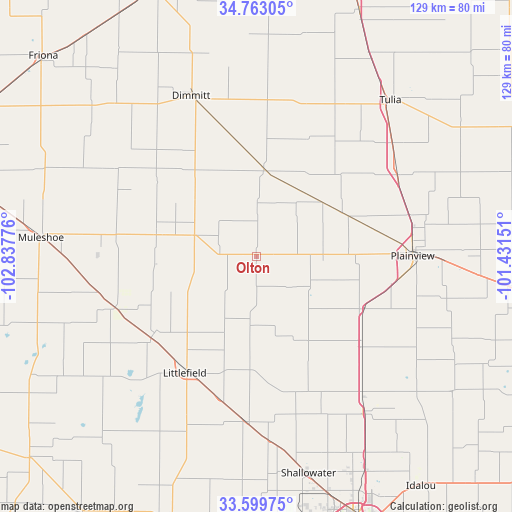
Olton GPS coordinates[2]
34° 11' 0.276" North, 102° 8' 4.668" West
| Map corner | latitude | longitude |
|---|---|---|
| Upper-left | 34.76305°, | -102.83776° |
| Center: | 34.18341°, | -102.13463° |
| Lower-right: | 33.59975°, | -101.43151° |
| Map W x H: | 129.3×129.3 km | = 80.3×80.3mi |
| max Lat: | 71.29058° ⇑79% North |
| Olton: | 34.18341° |
| min Lat: | ⇓21% South 19.06759° |
| min Long | Olton | max Long |
| -171.73463° | -102.13463° | -66.98998° |
| W 18.1%⇐ | ⇒81.9% E |
Elevation
Elevation of Olton is 1103 m = 3619 ft, and this is 808.2 m = 2652 ft above average elevation for this country.
| Max E: |
3189 m = 10463 ft | 6% |
| Olton | 1103 m 3619 ft | |
| Avg. | 294.8 m = 967 ft | |
Min E: |
-60 m = -197 ft | 94% |
See also: United States elevation on elevation.city.
Geographical zone
Olton is located in North temperate zone (between Tropic of Cancer and the Arctic Circle). Distance of this Northern Tropic circle is 1194.9 km =742.5 mi to South.| Distance of | km | miles | from Olton |
|---|---|---|---|
| North Pole | 6206.2 | 3856.4 | to North |
| Arctic Circle | 3600.3 | 2237.1 | to North |
| Tropic Cancer | 1194.9 | 742.5 | to South |
| Equator | 3800.8 | 2361.7 | to South |


Nearby cities:
15 places around Olton: (largest is in red/bold)
• Abernathy
47.4 km =29.5 mi,  145°
145°
• Amherst
32.2 km =20 mi,  233°
233°
• Anton
41.5 km =25.8 mi,  183°
183°
• Dimmitt
44 km =27.3 mi,  338°
338°
• Earth
26 km =16.2 mi,  282°
282°
• Hale Center
29.9 km =18.6 mi,  116°
116°
• Hart
22.5 km =14 mi,  4°
4°
• Kress
40.9 km =25.4 mi,  60°
60°
• Littlefield
34.4 km =21.4 mi,  210°
210°
• Muleshoe
54.4 km =33.8 mi, 275°
• Plainview
39.3 km =24.4 mi,  89°
89°
• Seth Ward
41 km =25.5 mi, 85°
• Shallowater
56.4 km =35 mi,  167°
167°
• Sudan
38.1 km =23.7 mi,  250°
250°
• Tulia
52.2 km =32.4 mi,  41°
41°
Sources, notices
• [Note1] Compared only with cities in United States existing in our database
• [Src1] Map data: © OpenStreetMap contributors (CC-BY-SA)
• [Src2] Other city data from geonames.org with taken over terms of usage.
• [Src3] Geographical zone / Annual Mean Temperature by Robert A. Rohde @ Wikipedia
