Ransom Canyon geodata
Ransom Canyon (Texas) is a populated place; located in United States in America/Chicago (GMT-5) time zone. With population of 1,131 people, there are 15501 cities with bigger population in this country. Compared to other cities in United States, 83% of cities are located further ↑North; 81.6% of cities are located further →East and 93.1% of cities have lower elevation than Ransom Canyon. Note1


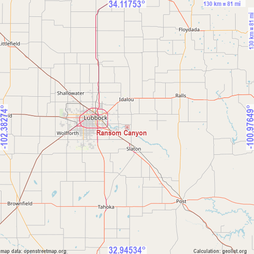
Ransom Canyon GPS coordinates[2]
33° 32' 0.312" North, 101° 40' 46.596" West
| Map corner | latitude | longitude |
|---|---|---|
| Upper-left | 34.11753°, | -102.38274° |
| Center: | 33.53342°, | -101.67961° |
| Lower-right: | 32.94534°, | -100.97649° |
| Map W x H: | 130.3×130.3 km | = 81×81mi |
| max Lat: | 71.29058° ⇑83% North |
| Ransom Canyon: | 33.53342° |
| min Lat: | ⇓17% South 19.06759° |
| min Long | Ransom Canyon | max Long |
| -171.73463° | -101.67961° | -66.98998° |
| W 18.4%⇐ | ⇒81.6% E |
Elevation
Elevation of Ransom Canyon is 945 m = 3100 ft, and this is 650.2 m = 2133 ft above average elevation for this country.
| Max E: |
3189 m = 10463 ft | 6.9% |
| Ransom Canyon | 945 m 3100 ft | |
| Avg. | 294.8 m = 967 ft | |
Min E: |
-60 m = -197 ft | 93.1% |
See also: United States elevation on elevation.city.
Geographical zone
Ransom Canyon is located in North temperate zone (between Tropic of Cancer and the Arctic Circle). Distance of this Northern Tropic circle is 1122.6 km =697.6 mi to South.| Distance of | km | miles | from Ransom Canyon |
|---|---|---|---|
| North Pole | 6278.5 | 3901.3 | to North |
| Arctic Circle | 3672.6 | 2282 | to North |
| Tropic Cancer | 1122.6 | 697.6 | to South |
| Equator | 3728.6 | 2316.8 | to South |


Nearby cities:
15 places around Ransom Canyon: (largest is in red/bold)
• Abernathy
36.5 km =22.7 mi,  335°
335°
• Anton
54.4 km =33.8 mi,  304°
304°
• Crosbyton
43.3 km =26.9 mi,  71°
71°
• Idalou
14.8 km =9.2 mi,  358°
358°
• Lorenzo
20.3 km =12.6 mi,  41°
41°
• Lubbock
17 km =10.6 mi,  286°
286°
• Meadow
53.5 km =33.2 mi,  245°
245°
• New Deal
26.9 km =16.7 mi,  327°
327°
• Petersburg
38.1 km =23.7 mi,  11°
11°
• Post
47.2 km =29.3 mi,  143°
143°
• Ralls
31.2 km =19.4 mi,  59°
59°
• Shallowater
34.2 km =21.3 mi, 300°
• Slaton
11.2 km =7 mi,  162°
162°
• Tahoka
42.1 km =26.2 mi,  194°
194°
• Wolfforth
30.7 km =19.1 mi,  264°
264°
Sources, notices
• [Note1] Compared only with cities in United States existing in our database
• [Src1] Map data: © OpenStreetMap contributors (CC-BY-SA)
• [Src2] Other city data from geonames.org with taken over terms of usage.
• [Src3] Geographical zone / Annual Mean Temperature by Robert A. Rohde @ Wikipedia
