Alpine geodata
Alpine (Texas) is a seat of a second-order administrative division; located in United States in America/Chicago (GMT-5) time zone. With population of 5,952 people, there are 6440 cities with bigger population in this country. Compared to other cities in United States, 92.3% of cities are located further ↑North; 82.5% of cities are located further →East and 95.7% of cities have lower elevation than Alpine. Note1


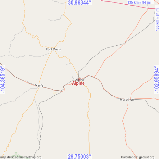
Alpine GPS coordinates[2]
30° 21' 31.032" North, 103° 39' 43.416" West
| Map corner | latitude | longitude |
|---|---|---|
| Upper-left | 30.96344°, | -104.36519° |
| Center: | 30.35862°, | -103.66206° |
| Lower-right: | 29.75003°, | -102.95894° |
| Map W x H: | 134.9×134.9 km | = 83.8×83.8mi |
| max Lat: | 71.29058° ⇑92.3% North |
| Alpine: | 30.35862° |
| min Lat: | ⇓7.7% South 19.06759° |
| min Long | Alpine | max Long |
| -171.73463° | -103.66206° | -66.98998° |
| W 17.5%⇐ | ⇒82.5% E |
Elevation
Elevation of Alpine is 1367 m = 4485 ft, and this is 1072.2 m = 3518 ft above average elevation for this country.
| Max E: |
3189 m = 10463 ft | 4.3% |
| Alpine | 1367 m 4485 ft | |
| Avg. | 294.8 m = 967 ft | |
Min E: |
-60 m = -197 ft | 95.7% |
See also: United States elevation on elevation.city.
Geographical zone
Alpine is located in North temperate zone (between Tropic of Cancer and the Arctic Circle). Distance of this Northern Tropic circle is 769.6 km =478.2 mi to South.| Distance of | km | miles | from Alpine |
|---|---|---|---|
| North Pole | 6631.5 | 4120.6 | to North |
| Arctic Circle | 4025.6 | 2501.4 | to North |
| Tropic Cancer | 769.6 | 478.2 | to South |
| Equator | 3375.6 | 2097.5 | to South |


Nearby cities:
15 places around Alpine: (largest is in red/bold)
• Balmorhea
70 km =43.5 mi,  353°
353°
• Crane
170.3 km =105.8 mi,  47°
47°
• Fort Davis
33.9 km =21.1 mi,  318°
318°
• Fort Stockton
95.7 km =59.5 mi, 51°
• Marfa
34.9 km =21.7 mi,  261°
261°
• McCamey
162.3 km =100.8 mi,  57°
57°
• Mentone
149.8 km =93.1 mi,  2°
2°
• Monahans
155.7 km =96.7 mi,  28°
28°
• Pecos
119.4 km =74.2 mi,  7°
7°
• Presidio
112 km =69.6 mi,  217°
217°
• Sanderson
124.1 km =77.1 mi,  101°
101°
• Thorntonville
153.4 km =95.3 mi, 27°
• Van Horn
135 km =83.9 mi,  304°
304°
• Wickett
148.7 km =92.4 mi, 25°
• Wink
162.1 km =100.7 mi,  17°
17°
Sources, notices
• [Note1] Compared only with cities in United States existing in our database
• [Src1] Map data: © OpenStreetMap contributors (CC-BY-SA)
• [Src2] Other city data from geonames.org with taken over terms of usage.
• [Src3] Geographical zone / Annual Mean Temperature by Robert A. Rohde @ Wikipedia
