Pecos geodata
Pecos (Texas) is a seat of a second-order administrative division; located in United States in America/Chicago (GMT-5) time zone. With population of 9,517 people, there are 4613 cities with bigger population in this country. Compared to other cities in United States, 89.8% of cities are located further ↑North; 82.5% of cities are located further →East and 91.9% of cities have lower elevation than Pecos. Note1


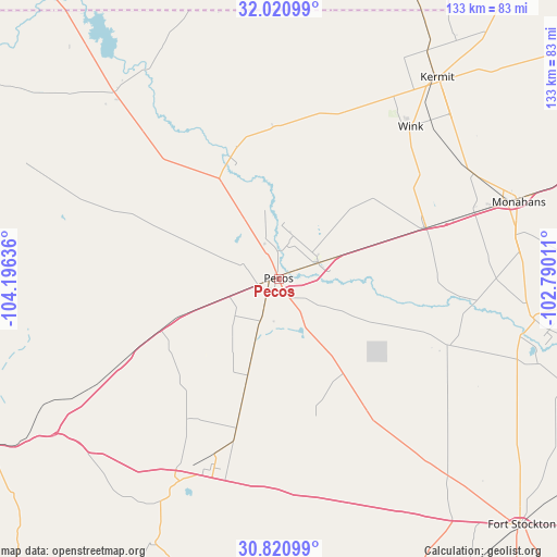
Pecos GPS coordinates[2]
31° 25' 22.476" North, 103° 29' 35.628" West
| Map corner | latitude | longitude |
|---|---|---|
| Upper-left | 32.02099°, | -104.19636° |
| Center: | 31.42291°, | -103.49323° |
| Lower-right: | 30.82099°, | -102.79011° |
| Map W x H: | 133.4×133.4 km | = 82.9×82.9mi |
| max Lat: | 71.29058° ⇑89.8% North |
| Pecos: | 31.42291° |
| min Lat: | ⇓10.2% South 19.06759° |
| min Long | Pecos | max Long |
| -171.73463° | -103.49323° | -66.98998° |
| W 17.5%⇐ | ⇒82.5% E |
Elevation
Elevation of Pecos is 791 m = 2595 ft, and this is 496.2 m = 1628 ft above average elevation for this country.
| Max E: |
3189 m = 10463 ft | 8.1% |
| Pecos | 791 m 2595 ft | |
| Avg. | 294.8 m = 967 ft | |
Min E: |
-60 m = -197 ft | 91.9% |
See also: United States elevation on elevation.city.
Geographical zone
Pecos is located in North temperate zone (between Tropic of Cancer and the Arctic Circle). Distance of this Northern Tropic circle is 888 km =551.8 mi to South.| Distance of | km | miles | from Pecos |
|---|---|---|---|
| North Pole | 6513.2 | 4047.1 | to North |
| Arctic Circle | 3907.3 | 2427.9 | to North |
| Tropic Cancer | 888 | 551.8 | to South |
| Equator | 3493.9 | 2171 | to South |


Nearby cities:
15 places around Pecos: (largest is in red/bold)
• Balmorhea
54.3 km =33.7 mi,  206°
206°
• Crane
108.5 km =67.4 mi,  91°
91°
• Eunice
117.1 km =72.8 mi,  15°
15°
• Fort Davis
100.4 km =62.4 mi,  202°
202°
• Fort Stockton
82.9 km =51.5 mi,  135°
135°
• Jal
81.8 km =50.8 mi, 20°
• Kermit
61.4 km =38.2 mi,  38°
38°
• Loving
111.6 km =69.3 mi,  329°
329°
• Mentone
33 km =20.5 mi,  342°
342°
• Monahans
60 km =37.3 mi,  71°
71°
• Odessa
116.5 km =72.4 mi, 66°
• Thorntonville
57.1 km =35.5 mi, 71°
• West Odessa
105.1 km =65.3 mi,  63°
63°
• Wickett
49.5 km =30.8 mi, 70°
• Wink
48.3 km =30 mi, 40°
Sources, notices
• [Note1] Compared only with cities in United States existing in our database
• [Src1] Map data: © OpenStreetMap contributors (CC-BY-SA)
• [Src2] Other city data from geonames.org with taken over terms of usage.
• [Src3] Geographical zone / Annual Mean Temperature by Robert A. Rohde @ Wikipedia
