Thorntonville geodata
Thorntonville (Texas) is a populated place; located in United States in America/Chicago (GMT-5) time zone. With population of 518 people, there are 20655 cities with bigger population in this country. Compared to other cities in United States, 89.5% of cities are located further ↑North; 82.2% of cities are located further →East and 92% of cities have lower elevation than Thorntonville. Note1


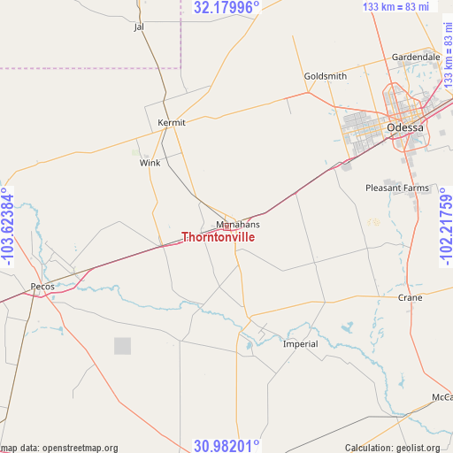
Thorntonville GPS coordinates[2]
31° 34' 58.476" North, 102° 55' 14.556" West
| Map corner | latitude | longitude |
|---|---|---|
| Upper-left | 32.17996°, | -103.62384° |
| Center: | 31.58291°, | -102.92071° |
| Lower-right: | 30.98201°, | -102.21759° |
| Map W x H: | 133.2×133.2 km | = 82.8×82.8mi |
| max Lat: | 71.29058° ⇑89.5% North |
| Thorntonville: | 31.58291° |
| min Lat: | ⇓10.5% South 19.06759° |
| min Long | Thorntonville | max Long |
| -171.73463° | -102.92071° | -66.98998° |
| W 17.8%⇐ | ⇒82.2% E |
Elevation
Elevation of Thorntonville is 794 m = 2605 ft, and this is 499.2 m = 1638 ft above average elevation for this country.
| Max E: |
3189 m = 10463 ft | 8% |
| Thorntonville | 794 m 2605 ft | |
| Avg. | 294.8 m = 967 ft | |
Min E: |
-60 m = -197 ft | 92% |
See also: United States elevation on elevation.city.
Geographical zone
Thorntonville is located in North temperate zone (between Tropic of Cancer and the Arctic Circle). Distance of this Northern Tropic circle is 905.8 km =562.8 mi to South.| Distance of | km | miles | from Thorntonville |
|---|---|---|---|
| North Pole | 6495.4 | 4036.1 | to North |
| Arctic Circle | 3889.5 | 2416.8 | to North |
| Tropic Cancer | 905.8 | 562.8 | to South |
| Equator | 3511.7 | 2182.1 | to South |


Nearby cities:
15 places around Thorntonville: (largest is in red/bold)
• Andrews
89.1 km =55.4 mi,  23°
23°
• Crane
57.9 km =36 mi,  110°
110°
• Fort Stockton
76.7 km =47.7 mi,  177°
177°
• Gardendale
70.5 km =43.8 mi,  46°
46°
• Jal
64.3 km =40 mi,  336°
336°
• Kermit
34.6 km =21.5 mi,  331°
331°
• McCamey
82.7 km =51.4 mi,  126°
126°
• McKinney Acres
88.1 km =54.7 mi, 24°
• Mentone
65.7 km =40.8 mi,  281°
281°
• Monahans
2.9 km =1.8 mi,  64°
64°
• Odessa
59.9 km =37.2 mi, 60°
• Pecos
57.1 km =35.5 mi,  251°
251°
• West Odessa
49.2 km =30.6 mi, 54°
• Wickett
7.7 km =4.8 mi,  259°
259°
• Wink
29.4 km =18.3 mi,  309°
309°
Sources, notices
• [Note1] Compared only with cities in United States existing in our database
• [Src1] Map data: © OpenStreetMap contributors (CC-BY-SA)
• [Src2] Other city data from geonames.org with taken over terms of usage.
• [Src3] Geographical zone / Annual Mean Temperature by Robert A. Rohde @ Wikipedia
