McCamey geodata
McCamey (Texas) is a populated place; located in United States in America/Chicago (GMT-5) time zone. With population of 2,062 people, there are 11751 cities with bigger population in this country. Compared to other cities in United States, 90.5% of cities are located further ↑North; 81.9% of cities are located further →East and 91.5% of cities have lower elevation than McCamey. Note1


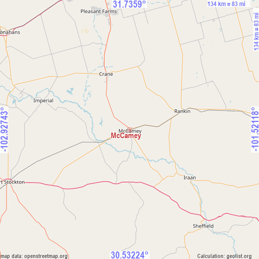
McCamey GPS coordinates[2]
31° 8' 9.528" North, 102° 13' 27.48" West
| Map corner | latitude | longitude |
|---|---|---|
| Upper-left | 31.7359°, | -102.92743° |
| Center: | 31.13598°, | -102.2243° |
| Lower-right: | 30.53224°, | -101.52118° |
| Map W x H: | 133.8×133.8 km | = 83.1×83.1mi |
| max Lat: | 71.29058° ⇑90.5% North |
| McCamey: | 31.13598° |
| min Lat: | ⇓9.5% South 19.06759° |
| min Long | McCamey | max Long |
| -171.73463° | -102.2243° | -66.98998° |
| W 18.1%⇐ | ⇒81.9% E |
Elevation
Elevation of McCamey is 750 m = 2461 ft, and this is 455.2 m = 1493 ft above average elevation for this country.
| Max E: |
3189 m = 10463 ft | 8.5% |
| McCamey | 750 m 2461 ft | |
| Avg. | 294.8 m = 967 ft | |
Min E: |
-60 m = -197 ft | 91.5% |
See also: United States elevation on elevation.city.
Geographical zone
McCamey is located in North temperate zone (between Tropic of Cancer and the Arctic Circle). Distance of this Northern Tropic circle is 856.1 km =532 mi to South.| Distance of | km | miles | from McCamey |
|---|---|---|---|
| North Pole | 6545.1 | 4066.9 | to North |
| Arctic Circle | 3939.2 | 2447.7 | to North |
| Tropic Cancer | 856.1 | 532 | to South |
| Equator | 3462 | 2151.2 | to South |


Nearby cities:
15 places around McCamey: (largest is in red/bold)
• Big Lake
72.9 km =45.3 mi,  85°
85°
• Crane
31.4 km =19.5 mi,  337°
337°
• Fort Stockton
68 km =42.3 mi,  246°
246°
• Garden City
107.3 km =66.7 mi,  41°
41°
• Gardendale
99.4 km =61.8 mi,  351°
351°
• Iraan
39.7 km =24.7 mi,  128°
128°
• Midland
96.8 km =60.1 mi,  8°
8°
• Monahans
81.4 km =50.6 mi,  308°
308°
• Odessa
80.1 km =49.8 mi, 350°
• Ozona
108.5 km =67.4 mi,  115°
115°
• Rankin
28.9 km =18 mi,  70°
70°
• Sanderson
111.7 km =69.4 mi,  188°
188°
• Thorntonville
82.7 km =51.4 mi, 306°
• West Odessa
82.7 km =51.4 mi, 341°
• Wickett
88.1 km =54.7 mi,  303°
303°
Sources, notices
• [Note1] Compared only with cities in United States existing in our database
• [Src1] Map data: © OpenStreetMap contributors (CC-BY-SA)
• [Src2] Other city data from geonames.org with taken over terms of usage.
• [Src3] Geographical zone / Annual Mean Temperature by Robert A. Rohde @ Wikipedia
