Borger geodata
Borger (Texas) is a populated place; located in United States in America/Chicago (GMT-5) time zone. With population of 12,964 people, there are 3688 cities with bigger population in this country. Compared to other cities in United States, 71.9% of cities are located further ↑North; 81.5% of cities are located further →East and 93% of cities have lower elevation than Borger. Note1


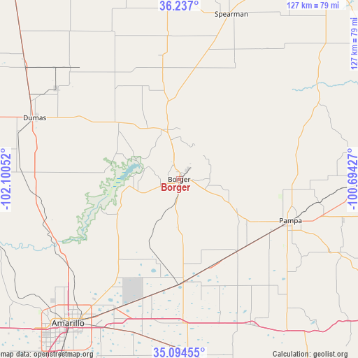
Borger GPS coordinates[2]
35° 40' 4.152" North, 101° 23' 50.604" West
| Map corner | latitude | longitude |
|---|---|---|
| Upper-left | 36.237°, | -102.10052° |
| Center: | 35.66782°, | -101.39739° |
| Lower-right: | 35.09455°, | -100.69427° |
| Map W x H: | 127×127 km | = 78.9×78.9mi |
| max Lat: | 71.29058° ⇑71.9% North |
| Borger: | 35.66782° |
| min Lat: | ⇓28.1% South 19.06759° |
| min Long | Borger | max Long |
| -171.73463° | -101.39739° | -66.98998° |
| W 18.5%⇐ | ⇒81.5% E |
Elevation
Elevation of Borger is 944 m = 3097 ft, and this is 649.2 m = 2130 ft above average elevation for this country.
| Max E: |
3189 m = 10463 ft | 7% |
| Borger | 944 m 3097 ft | |
| Avg. | 294.8 m = 967 ft | |
Min E: |
-60 m = -197 ft | 93% |
See also: United States elevation on elevation.city.
Geographical zone
Borger is located in North temperate zone (between Tropic of Cancer and the Arctic Circle). Distance of this Northern Tropic circle is 1360 km =845.1 mi to South.| Distance of | km | miles | from Borger |
|---|---|---|---|
| North Pole | 6041.2 | 3753.8 | to North |
| Arctic Circle | 3435.3 | 2134.6 | to North |
| Tropic Cancer | 1360 | 845.1 | to South |
| Equator | 3965.9 | 2464.3 | to South |


Nearby cities:
15 places around Borger: (largest is in red/bold)
• Amarillo
63.3 km =39.3 mi,  218°
218°
• Cactus
69.3 km =43.1 mi,  308°
308°
• Claude
61.9 km =38.5 mi,  177°
177°
• Dumas
56.4 km =35 mi,  292°
292°
• Fritch
18.9 km =11.7 mi,  260°
260°
• Groom
57.9 km =36 mi,  152°
152°
• Gruver
66.4 km =41.3 mi,  359°
359°
• Lefors
59.4 km =36.9 mi,  115°
115°
• Miami
68.6 km =42.6 mi,  87°
87°
• Pampa
42.2 km =26.2 mi,  110°
110°
• Panhandle
35.9 km =22.3 mi, 177°
• Spearman
61.8 km =38.4 mi,  17°
17°
• Stinnett
18.2 km =11.3 mi,  346°
346°
• Sunray
54.7 km =34 mi,  315°
315°
• White Deer
32.9 km =20.4 mi,  141°
141°
Sources, notices
• [Note1] Compared only with cities in United States existing in our database
• [Src1] Map data: © OpenStreetMap contributors (CC-BY-SA)
• [Src2] Other city data from geonames.org with taken over terms of usage.
• [Src3] Geographical zone / Annual Mean Temperature by Robert A. Rohde @ Wikipedia
