Fritch geodata
Fritch (Texas) is a populated place; located in United States in America/Chicago (GMT-5) time zone. With population of 2,066 people, there are 11732 cities with bigger population in this country. Compared to other cities in United States, 72% of cities are located further ↑North; 81.6% of cities are located further →East and 93.3% of cities have lower elevation than Fritch. Note1


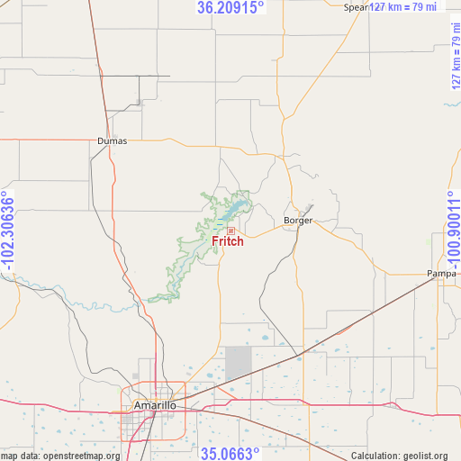
Fritch GPS coordinates[2]
35° 38' 23.172" North, 101° 36' 11.628" West
| Map corner | latitude | longitude |
|---|---|---|
| Upper-left | 36.20915°, | -102.30636° |
| Center: | 35.63977°, | -101.60323° |
| Lower-right: | 35.0663°, | -100.90011° |
| Map W x H: | 127.1×127.1 km | = 79×79mi |
| max Lat: | 71.29058° ⇑72% North |
| Fritch: | 35.63977° |
| min Lat: | ⇓28% South 19.06759° |
| min Long | Fritch | max Long |
| -171.73463° | -101.60323° | -66.98998° |
| W 18.4%⇐ | ⇒81.6% E |
Elevation
Elevation of Fritch is 980 m = 3215 ft, and this is 685.2 m = 2248 ft above average elevation for this country.
| Max E: |
3189 m = 10463 ft | 6.7% |
| Fritch | 980 m 3215 ft | |
| Avg. | 294.8 m = 967 ft | |
Min E: |
-60 m = -197 ft | 93.3% |
See also: United States elevation on elevation.city.
Geographical zone
Fritch is located in North temperate zone (between Tropic of Cancer and the Arctic Circle). Distance of this Northern Tropic circle is 1356.9 km =843.1 mi to South.| Distance of | km | miles | from Fritch |
|---|---|---|---|
| North Pole | 6044.3 | 3755.8 | to North |
| Arctic Circle | 3438.4 | 2136.5 | to North |
| Tropic Cancer | 1356.9 | 843.1 | to South |
| Equator | 3962.8 | 2462.4 | to South |


Nearby cities:
15 places around Fritch: (largest is in red/bold)
• Amarillo
50.8 km =31.6 mi,  203°
203°
• Borger
18.9 km =11.7 mi,  80°
80°
• Bushland
65 km =40.4 mi,  220°
220°
• Cactus
58.3 km =36.2 mi,  321°
321°
• Channing
65.9 km =40.9 mi,  274°
274°
• Claude
62.6 km =38.9 mi,  159°
159°
• Dumas
41.8 km =26 mi,  306°
306°
• Groom
66.1 km =41.1 mi,  137°
137°
• Gruver
71.7 km =44.6 mi,  14°
14°
• Lake Tanglewood
65.8 km =40.9 mi,  194°
194°
• Pampa
59.3 km =36.8 mi,  101°
101°
• Panhandle
38.4 km =23.9 mi,  148°
148°
• Stinnett
25.3 km =15.7 mi,  34°
34°
• Sunray
46.4 km =28.8 mi,  334°
334°
• White Deer
45.1 km =28 mi,  120°
120°
Sources, notices
• [Note1] Compared only with cities in United States existing in our database
• [Src1] Map data: © OpenStreetMap contributors (CC-BY-SA)
• [Src2] Other city data from geonames.org with taken over terms of usage.
• [Src3] Geographical zone / Annual Mean Temperature by Robert A. Rohde @ Wikipedia
