Panhandle geodata
Panhandle (Texas) is a seat of a second-order administrative division; located in United States in America/Chicago (GMT-5) time zone. With population of 2,341 people, there are 10990 cities with bigger population in this country. Compared to other cities in United States, 73.4% of cities are located further ↑North; 81.5% of cities are located further →East and 93.8% of cities have lower elevation than Panhandle. Note1


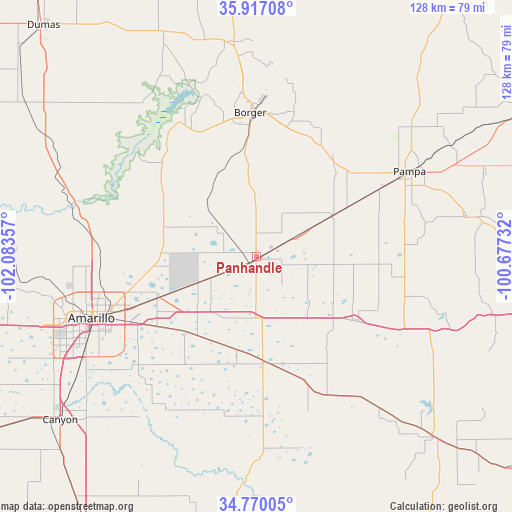
Panhandle GPS coordinates[2]
35° 20' 44.16" North, 101° 22' 49.584" West
| Map corner | latitude | longitude |
|---|---|---|
| Upper-left | 35.91708°, | -102.08357° |
| Center: | 35.3456°, | -101.38044° |
| Lower-right: | 34.77005°, | -100.67732° |
| Map W x H: | 127.5×127.5 km | = 79.2×79.2mi |
| max Lat: | 71.29058° ⇑73.4% North |
| Panhandle: | 35.3456° |
| min Lat: | ⇓26.6% South 19.06759° |
| min Long | Panhandle | max Long |
| -171.73463° | -101.38044° | -66.98998° |
| W 18.5%⇐ | ⇒81.5% E |
Elevation
Elevation of Panhandle is 1057 m = 3468 ft, and this is 762.2 m = 2501 ft above average elevation for this country.
| Max E: |
3189 m = 10463 ft | 6.2% |
| Panhandle | 1057 m 3468 ft | |
| Avg. | 294.8 m = 967 ft | |
Min E: |
-60 m = -197 ft | 93.8% |
See also: United States elevation on elevation.city.
Geographical zone
Panhandle is located in North temperate zone (between Tropic of Cancer and the Arctic Circle). Distance of this Northern Tropic circle is 1324.1 km =822.8 mi to South.| Distance of | km | miles | from Panhandle |
|---|---|---|---|
| North Pole | 6077 | 3776.1 | to North |
| Arctic Circle | 3471.1 | 2156.8 | to North |
| Tropic Cancer | 1324.1 | 822.8 | to South |
| Equator | 3930.1 | 2442.1 | to South |


Nearby cities:
15 places around Panhandle: (largest is in red/bold)
• Amarillo
43.2 km =26.8 mi,  251°
251°
• Borger
35.9 km =22.3 mi,  357°
357°
• Bushland
64.4 km =40 mi, 254°
• Canyon
63.6 km =39.5 mi,  230°
230°
• Clarendon
63.7 km =39.6 mi,  135°
135°
• Claude
26.1 km =16.2 mi,  176°
176°
• Fritch
38.4 km =23.9 mi,  328°
328°
• Groom
29.4 km =18.3 mi,  122°
122°
• Lake Tanglewood
48.2 km =30 mi, 230°
• Lefors
53.1 km =33 mi,  79°
79°
• McLean
72 km =44.7 mi,  100°
100°
• Miami
77.4 km =48.1 mi,  60°
60°
• Pampa
43.6 km =27.1 mi, 60°
• Stinnett
53.8 km =33.4 mi,  353°
353°
• White Deer
21.3 km =13.2 mi, 62°
Sources, notices
• [Note1] Compared only with cities in United States existing in our database
• [Src1] Map data: © OpenStreetMap contributors (CC-BY-SA)
• [Src2] Other city data from geonames.org with taken over terms of usage.
• [Src3] Geographical zone / Annual Mean Temperature by Robert A. Rohde @ Wikipedia
