Amarillo geodata
Amarillo (Texas) is a seat of a second-order administrative division; located in United States in America/Chicago (GMT-5) time zone. With population of 198,645 people, there are 130 cities with bigger population in this country. Compared to other cities in United States, 74.2% of cities are located further ↑North; 81.8% of cities are located further →East and 94.2% of cities have lower elevation than Amarillo. Note1


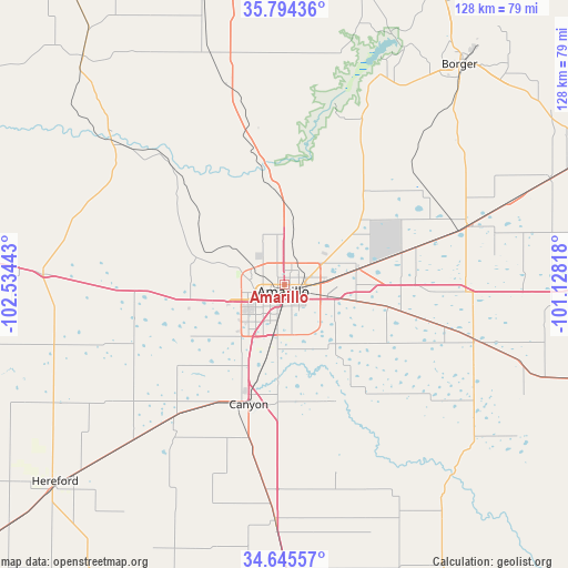
Amarillo GPS coordinates[2]
35° 13' 19.2" North, 101° 49' 52.68" West
| Map corner | latitude | longitude |
|---|---|---|
| Upper-left | 35.79436°, | -102.53443° |
| Center: | 35.222°, | -101.8313° |
| Lower-right: | 34.64557°, | -101.12818° |
| Map W x H: | 127.7×127.7 km | = 79.3×79.3mi |
| max Lat: | 71.29058° ⇑74.2% North |
| Amarillo: | 35.222° |
| min Lat: | ⇓25.8% South 19.06759° |
| min Long | Amarillo | max Long |
| -171.73463° | -101.8313° | -66.98998° |
| W 18.2%⇐ | ⇒81.8% E |
Elevation
Elevation of Amarillo is 1124 m = 3688 ft, and this is 829.2 m = 2720 ft above average elevation for this country.
| Max E: |
3189 m = 10463 ft | 5.8% |
| Amarillo | 1124 m 3688 ft | |
| Avg. | 294.8 m = 967 ft | |
Min E: |
-60 m = -197 ft | 94.2% |
See also: Amarillo elevation on elevation.city.
Geographical zone
Amarillo is located in North temperate zone (between Tropic of Cancer and the Arctic Circle). Distance of this Northern Tropic circle is 1310.4 km =814.2 mi to South.| Distance of | km | miles | from Amarillo |
|---|---|---|---|
| North Pole | 6090.7 | 3784.6 | to North |
| Arctic Circle | 3484.9 | 2165.4 | to North |
| Tropic Cancer | 1310.4 | 814.2 | to South |
| Equator | 3916.3 | 2433.5 | to South |


Nearby cities:
15 places around Amarillo: (largest is in red/bold)
• Borger
63.3 km =39.3 mi,  38°
38°
• Bushland
21.5 km =13.4 mi,  261°
261°
• Canyon
28 km =17.4 mi,  196°
196°
• Channing
68.4 km =42.5 mi,  318°
318°
• Claude
44.3 km =27.5 mi,  106°
106°
• Dumas
72.7 km =45.2 mi,  349°
349°
• Fritch
50.8 km =31.6 mi,  23°
23°
• Groom
65.8 km =40.9 mi,  91°
91°
• Happy
53.2 km =33.1 mi,  182°
182°
• Hereford
68.7 km =42.7 mi,  228°
228°
• Lake Tanglewood
17.6 km =10.9 mi,  166°
166°
• Panhandle
43.2 km =26.8 mi,  71°
71°
• Stinnett
75.9 km =47.2 mi,  27°
27°
• Vega
54.3 km =33.7 mi,  272°
272°
• White Deer
64.3 km =40 mi, 68°
Sources, notices
• [Note1] Compared only with cities in United States existing in our database
• [Src1] Map data: © OpenStreetMap contributors (CC-BY-SA)
• [Src2] Other city data from geonames.org with taken over terms of usage.
• [Src3] Geographical zone / Annual Mean Temperature by Robert A. Rohde @ Wikipedia
