Uvalde geodata
Uvalde (Texas) is a seat of a second-order administrative division; located in United States in America/Chicago (GMT-5) time zone. With population of 16,476 people, there are 2979 cities with bigger population in this country. Compared to other cities in United States, 95% of cities are located further ↑North; 80.6% of cities are located further →East and 69% of cities have lower elevation than Uvalde. Note1


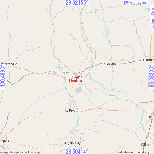
Uvalde GPS coordinates[2]
29° 12' 34.848" North, 99° 47' 10.212" West
| Map corner | latitude | longitude |
|---|---|---|
| Upper-left | 29.82155°, | -100.4893° |
| Center: | 29.20968°, | -99.78617° |
| Lower-right: | 28.59414°, | -99.08305° |
| Map W x H: | 136.5×136.5 km | = 84.8×84.8mi |
| max Lat: | 71.29058° ⇑95% North |
| Uvalde: | 29.20968° |
| min Lat: | ⇓5% South 19.06759° |
| min Long | Uvalde | max Long |
| -171.73463° | -99.78617° | -66.98998° |
| W 19.4%⇐ | ⇒80.6% E |
Elevation
Elevation of Uvalde is 281 m = 922 ft, and this is 13.8 m = 45 ft below average elevation for this country.
| Max E: |
3189 m = 10463 ft | 31% |
| Avg. | 294.8 m = 967 ft | |
| Uvalde | 281 m = 922 ft | |
Min E: |
-60 m = -197 ft | 69% |
See also: United States elevation on elevation.city.
Geographical zone
Uvalde is located in North temperate zone (between Tropic of Cancer and the Arctic Circle). Distance of this Northern Tropic circle is 641.9 km =398.9 mi to South.| Distance of | km | miles | from Uvalde |
|---|---|---|---|
| North Pole | 6759.2 | 4200 | to North |
| Arctic Circle | 4153.4 | 2580.8 | to North |
| Tropic Cancer | 641.9 | 398.9 | to South |
| Equator | 3247.8 | 2018.1 | to South |


Nearby cities:
15 places around Uvalde: (largest is in red/bold)
• Batesville
33.1 km =20.6 mi,  150°
150°
• Big Wells
73.9 km =45.9 mi,  163°
163°
• Brackettville
62.3 km =38.7 mi,  280°
280°
• Camp Wood
55.6 km =34.5 mi,  336°
336°
• Crystal City
59.3 km =36.8 mi,  183°
183°
• D'Hanis
50.9 km =31.6 mi,  74°
74°
• Fort Clark Springs
62.6 km =38.9 mi, 279°
• Hondo
64.4 km =40 mi,  76°
76°
• Knippa
17.3 km =10.7 mi,  56°
56°
• La Pryor
30.5 km =19 mi,  191°
191°
• Leakey
57.8 km =35.9 mi,  2°
2°
• North Pearsall
74.6 km =46.4 mi,  116°
116°
• Pearsall
75.9 km =47.2 mi, 117°
• Sabinal
33.2 km =20.6 mi, 68°
• Uvalde Estates
6.7 km =4.2 mi,  222°
222°
Sources, notices
• [Note1] Compared only with cities in United States existing in our database
• [Src1] Map data: © OpenStreetMap contributors (CC-BY-SA)
• [Src2] Other city data from geonames.org with taken over terms of usage.
• [Src3] Geographical zone / Annual Mean Temperature by Robert A. Rohde @ Wikipedia
