Uvalde Estates geodata
Uvalde Estates (Texas) is a populated place; located in United States in America/Chicago (GMT-5) time zone. With population of 2,171 people, there are 11413 cities with bigger population in this country. Compared to other cities in United States, 95.1% of cities are located further ↑North; 80.6% of cities are located further →East and 70.9% of cities have lower elevation than Uvalde Estates. Note1


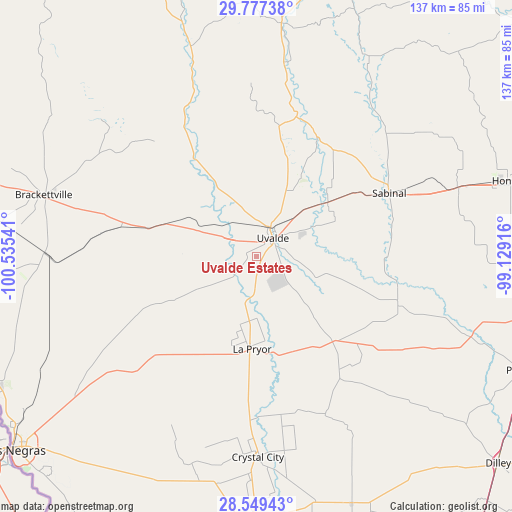
Uvalde Estates GPS coordinates[2]
29° 9' 54.864" North, 99° 49' 56.208" West
| Map corner | latitude | longitude |
|---|---|---|
| Upper-left | 29.77738°, | -100.53541° |
| Center: | 29.16524°, | -99.83228° |
| Lower-right: | 28.54943°, | -99.12916° |
| Map W x H: | 136.5×136.5 km | = 84.8×84.8mi |
| max Lat: | 71.29058° ⇑95.1% North |
| Uvalde Estates: | 29.16524° |
| min Lat: | ⇓4.9% South 19.06759° |
| min Long | Uvalde Estates | max Long |
| -171.73463° | -99.83228° | -66.98998° |
| W 19.4%⇐ | ⇒80.6% E |
Elevation
Elevation of Uvalde Estates is 290 m = 951 ft, and this is 4.8 m = 16 ft below average elevation for this country.
| Max E: |
3189 m = 10463 ft | 29.1% |
| Avg. | 294.8 m = 967 ft | |
| Uvalde Estates | 290 m = 951 ft | |
Min E: |
-60 m = -197 ft | 70.9% |
See also: United States elevation on elevation.city.
Geographical zone
Uvalde Estates is located in North temperate zone (between Tropic of Cancer and the Arctic Circle). Distance of this Northern Tropic circle is 637 km =395.8 mi to South.| Distance of | km | miles | from Uvalde Estates |
|---|---|---|---|
| North Pole | 6764.2 | 4203.1 | to North |
| Arctic Circle | 4158.3 | 2583.8 | to North |
| Tropic Cancer | 637 | 395.8 | to South |
| Equator | 3242.9 | 2015 | to South |


Nearby cities:
15 places around Uvalde Estates: (largest is in red/bold)
• Batesville
31.6 km =19.6 mi,  138°
138°
• Big Wells
70.6 km =43.9 mi,  158°
158°
• Brackettville
59.1 km =36.7 mi,  285°
285°
• Camp Wood
58.7 km =36.5 mi,  342°
342°
• Carrizo Hill
73.6 km =45.7 mi,  179°
179°
• Carrizo Springs
71.6 km =44.5 mi, 182°
• Crystal City
54.2 km =33.7 mi, 179°
• D'Hanis
56.7 km =35.2 mi,  71°
71°
• Fort Clark Springs
59.3 km =36.8 mi, 285°
• Hondo
70 km =43.5 mi, 73°
• Knippa
23.8 km =14.8 mi,  52°
52°
• La Pryor
25 km =15.5 mi, 183°
• Leakey
63 km =39.1 mi,  6°
6°
• Sabinal
39.3 km =24.4 mi,  64°
64°
• Uvalde
6.7 km =4.2 mi,  42°
42°
Sources, notices
• [Note1] Compared only with cities in United States existing in our database
• [Src1] Map data: © OpenStreetMap contributors (CC-BY-SA)
• [Src2] Other city data from geonames.org with taken over terms of usage.
• [Src3] Geographical zone / Annual Mean Temperature by Robert A. Rohde @ Wikipedia
