Floydada geodata
Floydada (Texas) is a seat of a second-order administrative division; located in United States in America/Chicago (GMT-5) time zone. With population of 2,775 people, there are 10032 cities with bigger population in this country. Compared to other cities in United States, 80.3% of cities are located further ↑North; 81.5% of cities are located further →East and 93.2% of cities have lower elevation than Floydada. Note1


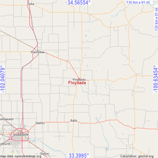
Floydada GPS coordinates[2]
33° 59' 4.272" North, 101° 20' 15.576" West
| Map corner | latitude | longitude |
|---|---|---|
| Upper-left | 34.56554°, | -102.04079° |
| Center: | 33.98452°, | -101.33766° |
| Lower-right: | 33.3995°, | -100.63454° |
| Map W x H: | 129.7×129.7 km | = 80.6×80.6mi |
| max Lat: | 71.29058° ⇑80.3% North |
| Floydada: | 33.98452° |
| min Lat: | ⇓19.7% South 19.06759° |
| min Long | Floydada | max Long |
| -171.73463° | -101.33766° | -66.98998° |
| W 18.5%⇐ | ⇒81.5% E |
Elevation
Elevation of Floydada is 973 m = 3192 ft, and this is 678.2 m = 2225 ft above average elevation for this country.
| Max E: |
3189 m = 10463 ft | 6.8% |
| Floydada | 973 m 3192 ft | |
| Avg. | 294.8 m = 967 ft | |
Min E: |
-60 m = -197 ft | 93.2% |
See also: United States elevation on elevation.city.
Geographical zone
Floydada is located in North temperate zone (between Tropic of Cancer and the Arctic Circle). Distance of this Northern Tropic circle is 1172.8 km =728.7 mi to South.| Distance of | km | miles | from Floydada |
|---|---|---|---|
| North Pole | 6228.3 | 3870.1 | to North |
| Arctic Circle | 3622.4 | 2250.9 | to North |
| Tropic Cancer | 1172.8 | 728.7 | to South |
| Equator | 3778.7 | 2348 | to South |


Nearby cities:
15 places around Floydada: (largest is in red/bold)
• Abernathy
49.6 km =30.8 mi,  250°
250°
• Crosbyton
37.2 km =23.1 mi,  165°
165°
• Hale Center
47.5 km =29.5 mi,  280°
280°
• Idalou
47.6 km =29.6 mi,  222°
222°
• Kress
56.8 km =35.3 mi,  318°
318°
• Lockney
18.3 km =11.4 mi,  328°
328°
• Lorenzo
39.4 km =24.5 mi,  207°
207°
• Matador
47.6 km =29.6 mi,  86°
86°
• New Deal
53.6 km =33.3 mi,  239°
239°
• Petersburg
27.2 km =16.9 mi, 241°
• Plainview
40.6 km =25.2 mi,  303°
303°
• Ralls
34.8 km =21.6 mi,  187°
187°
• Ransom Canyon
59.3 km =36.8 mi, 212°
• Seth Ward
41.1 km =25.5 mi,  307°
307°
• Silverton
54.5 km =33.9 mi,  3°
3°
Sources, notices
• [Note1] Compared only with cities in United States existing in our database
• [Src1] Map data: © OpenStreetMap contributors (CC-BY-SA)
• [Src2] Other city data from geonames.org with taken over terms of usage.
• [Src3] Geographical zone / Annual Mean Temperature by Robert A. Rohde @ Wikipedia
