Kress geodata
Kress (Texas) is a populated place; located in United States in America/Chicago (GMT-5) time zone. With population of 687 people, there are 18811 cities with bigger population in this country. Compared to other cities in United States, 78.2% of cities are located further ↑North; 81.7% of cities are located further →East and 93.8% of cities have lower elevation than Kress. Note1


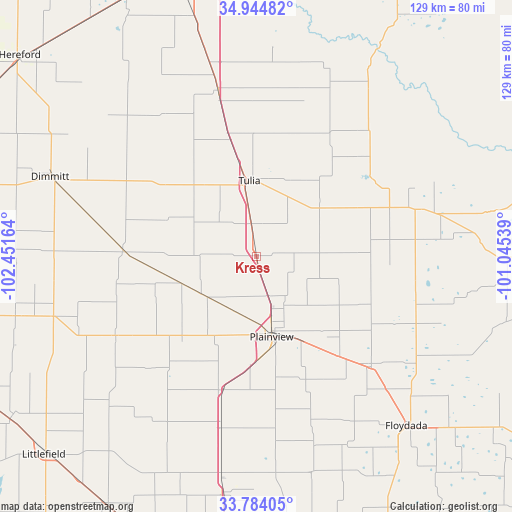
Kress GPS coordinates[2]
34° 21' 59.22" North, 101° 44' 54.636" West
| Map corner | latitude | longitude |
|---|---|---|
| Upper-left | 34.94482°, | -102.45164° |
| Center: | 34.36645°, | -101.74851° |
| Lower-right: | 33.78405°, | -101.04539° |
| Map W x H: | 129.1×129.1 km | = 80.2×80.2mi |
| max Lat: | 71.29058° ⇑78.2% North |
| Kress: | 34.36645° |
| min Lat: | ⇓21.8% South 19.06759° |
| min Long | Kress | max Long |
| -171.73463° | -101.74851° | -66.98998° |
| W 18.3%⇐ | ⇒81.7% E |
Elevation
Elevation of Kress is 1058 m = 3471 ft, and this is 763.2 m = 2504 ft above average elevation for this country.
| Max E: |
3189 m = 10463 ft | 6.2% |
| Kress | 1058 m 3471 ft | |
| Avg. | 294.8 m = 967 ft | |
Min E: |
-60 m = -197 ft | 93.8% |
See also: United States elevation on elevation.city.
Geographical zone
Kress is located in North temperate zone (between Tropic of Cancer and the Arctic Circle). Distance of this Northern Tropic circle is 1215.3 km =755.2 mi to South.| Distance of | km | miles | from Kress |
|---|---|---|---|
| North Pole | 6185.9 | 3843.7 | to North |
| Arctic Circle | 3580 | 2224.5 | to North |
| Tropic Cancer | 1215.3 | 755.2 | to South |
| Equator | 3821.2 | 2374.4 | to South |


Nearby cities:
15 places around Kress: (largest is in red/bold)
• Abernathy
60 km =37.3 mi,  188°
188°
• Canyon
70 km =43.5 mi,  347°
347°
• Dimmitt
55.6 km =34.5 mi,  291°
291°
• Earth
62.6 km =38.9 mi,  256°
256°
• Floydada
56.8 km =35.3 mi,  138°
138°
• Hale Center
34.7 km =21.6 mi, 194°
• Happy
43.1 km =26.8 mi, 346°
• Hart
33.8 km =21 mi,  273°
273°
• Lockney
39 km =24.2 mi,  133°
133°
• Olton
40.9 km =25.4 mi,  240°
240°
• Petersburg
57 km =35.4 mi,  165°
165°
• Plainview
20.6 km =12.8 mi, 169°
• Seth Ward
18 km =11.2 mi,  162°
162°
• Silverton
42.4 km =26.3 mi,  73°
73°
• Tulia
18.9 km =11.7 mi,  357°
357°
Sources, notices
• [Note1] Compared only with cities in United States existing in our database
• [Src1] Map data: © OpenStreetMap contributors (CC-BY-SA)
• [Src2] Other city data from geonames.org with taken over terms of usage.
• [Src3] Geographical zone / Annual Mean Temperature by Robert A. Rohde @ Wikipedia
