Kanab geodata
Kanab (Utah) is a seat of a second-order administrative division; located in United States in America/Denver (GMT-6) time zone. With population of 4,394 people, there are 7759 cities with bigger population in this country. Compared to other cities in United States, 66% of cities are located further ↑North; 88.1% of cities are located further →East and 96.8% of cities have lower elevation than Kanab. Note1


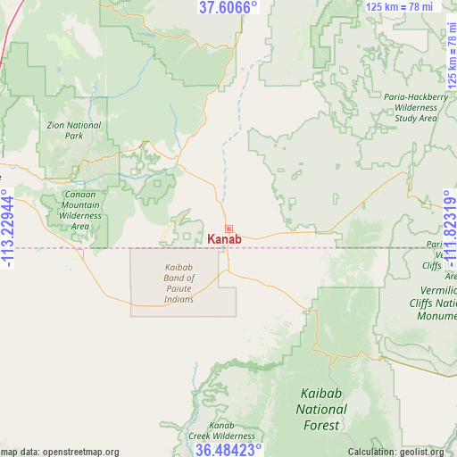
Kanab GPS coordinates[2]
37° 2' 50.964" North, 112° 31' 34.716" West
| Map corner | latitude | longitude |
|---|---|---|
| Upper-left | 37.6066°, | -113.22944° |
| Center: | 37.04749°, | -112.52631° |
| Lower-right: | 36.48423°, | -111.82319° |
| Map W x H: | 124.8×124.8 km | = 77.5×77.5mi |
| max Lat: | 71.29058° ⇑66% North |
| Kanab: | 37.04749° |
| min Lat: | ⇓34% South 19.06759° |
| min Long | Kanab | max Long |
| -171.73463° | -112.52631° | -66.98998° |
| W 11.9%⇐ | ⇒88.1% E |
Elevation
Elevation of Kanab is 1518 m = 4980 ft, and this is 1223.2 m = 4013 ft above average elevation for this country.
| Max E: |
3189 m = 10463 ft | 3.2% |
| Kanab | 1518 m 4980 ft | |
| Avg. | 294.8 m = 967 ft | |
Min E: |
-60 m = -197 ft | 96.8% |
See also: United States elevation on elevation.city.
Geographical zone
Kanab is located in North temperate zone (between Tropic of Cancer and the Arctic Circle). Distance of this Northern Tropic circle is 1513.4 km =940.4 mi to South.| Distance of | km | miles | from Kanab |
|---|---|---|---|
| North Pole | 5887.8 | 3658.5 | to North |
| Arctic Circle | 3281.9 | 2039.3 | to North |
| Tropic Cancer | 1513.4 | 940.4 | to South |
| Equator | 4119.3 | 2559.6 | to South |


Nearby cities:
15 places around Kanab: (largest is in red/bold)
• Apple Valley
53.3 km =33.1 mi,  275°
275°
• Cedar City
84.5 km =52.5 mi,  325°
325°
• Centennial Park
41.7 km =25.9 mi,  255°
255°
• Colorado City
40.4 km =25.1 mi, 260°
• Fredonia
11.3 km =7 mi,  180°
180°
• Hildale
39.4 km =24.5 mi, 262°
• Hurricane
69.2 km =43 mi, 281°
• LaVerkin
68.1 km =42.3 mi, 284°
• Leeds
76.8 km =47.7 mi,  286°
286°
• Orderville
27.2 km =16.9 mi,  338°
338°
• Panguitch
86.6 km =53.8 mi,  5°
5°
• Springdale
44.7 km =27.8 mi, 290°
• Toquerville
71 km =44.1 mi, 288°
• Tropic
75.3 km =46.8 mi,  31°
31°
• Virgin
61.3 km =38.1 mi, 286°
Sources, notices
• [Note1] Compared only with cities in United States existing in our database
• [Src1] Map data: © OpenStreetMap contributors (CC-BY-SA)
• [Src2] Other city data from geonames.org with taken over terms of usage.
• [Src3] Geographical zone / Annual Mean Temperature by Robert A. Rohde @ Wikipedia
