Orderville geodata
Orderville (Utah) is a populated place; located in United States in America/Denver (GMT-6) time zone. With population of 559 people, there are 20165 cities with bigger population in this country. Compared to other cities in United States, 64.9% of cities are located further ↑North; 88.1% of cities are located further →East and 97.8% of cities have lower elevation than Orderville. Note1


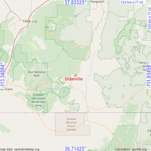
Orderville GPS coordinates[2]
37° 16' 32.952" North, 112° 38' 15.756" West
| Map corner | latitude | longitude |
|---|---|---|
| Upper-left | 37.83323°, | -113.34084° |
| Center: | 37.27582°, | -112.63771° |
| Lower-right: | 36.71425°, | -111.93459° |
| Map W x H: | 124.4×124.4 km | = 77.3×77.3mi |
| max Lat: | 71.29058° ⇑64.9% North |
| Orderville: | 37.27582° |
| min Lat: | ⇓35.1% South 19.06759° |
| min Long | Orderville | max Long |
| -171.73463° | -112.63771° | -66.98998° |
| W 11.9%⇐ | ⇒88.1% E |
Elevation
Elevation of Orderville is 1666 m = 5466 ft, and this is 1371.2 m = 4499 ft above average elevation for this country.
| Max E: |
3189 m = 10463 ft | 2.2% |
| Orderville | 1666 m 5466 ft | |
| Avg. | 294.8 m = 967 ft | |
Min E: |
-60 m = -197 ft | 97.8% |
See also: United States elevation on elevation.city.
Geographical zone
Orderville is located in North temperate zone (between Tropic of Cancer and the Arctic Circle). Distance of this Northern Tropic circle is 1538.8 km =956.2 mi to South.| Distance of | km | miles | from Orderville |
|---|---|---|---|
| North Pole | 5862.4 | 3642.7 | to North |
| Arctic Circle | 3256.5 | 2023.5 | to North |
| Tropic Cancer | 1538.8 | 956.2 | to South |
| Equator | 4144.7 | 2575.4 | to South |


Nearby cities:
15 places around Orderville: (largest is in red/bold)
• Apple Valley
47.8 km =29.7 mi,  244°
244°
• Cedar City
58.3 km =36.2 mi,  320°
320°
• Centennial Park
47 km =29.2 mi,  220°
220°
• Colorado City
43.7 km =27.2 mi, 223°
• Fredonia
38 km =23.6 mi,  164°
164°
• Hildale
42 km =26.1 mi, 223°
• Hurricane
58.8 km =36.5 mi,  259°
259°
• Kanab
27.2 km =16.9 mi, 158°
• LaVerkin
56.6 km =35.2 mi, 261°
• Leeds
64 km =39.8 mi,  266°
266°
• Panguitch
63.4 km =39.4 mi,  16°
16°
• Springdale
33.4 km =20.8 mi,  253°
253°
• Toquerville
57.3 km =35.6 mi, 267°
• Tropic
62.6 km =38.9 mi,  51°
51°
• Virgin
49.3 km =30.6 mi, 261°
Sources, notices
• [Note1] Compared only with cities in United States existing in our database
• [Src1] Map data: © OpenStreetMap contributors (CC-BY-SA)
• [Src2] Other city data from geonames.org with taken over terms of usage.
• [Src3] Geographical zone / Annual Mean Temperature by Robert A. Rohde @ Wikipedia
