Minersville geodata
Minersville (Utah) is a populated place; located in United States in America/Denver (GMT-6) time zone. With population of 869 people, there are 17207 cities with bigger population in this country. Compared to other cities in United States, 60.5% of cities are located further ↑North; 88.2% of cities are located further →East and 97.4% of cities have lower elevation than Minersville. Note1


Minersville GPS coordinates[2]
38° 12' 50.904" North, 112° 55' 24.816" West
| Map corner | latitude | longitude |
|---|---|---|
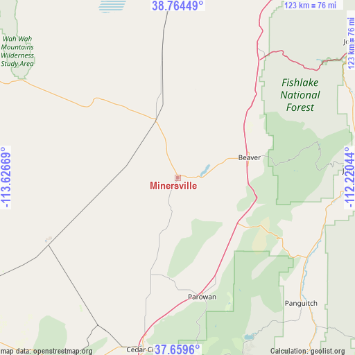
| Upper-left | 38.76449°, | -113.62669° |
| Center: | 38.21414°, | -112.92356° |
| Lower-right: | 37.6596°, | -112.22044° |
| Map W x H: | 122.9×122.9 km | = 76.4×76.4mi |
| max Lat: | 71.29058° ⇑60.5% North |
| Minersville: | 38.21414° |
| min Lat: | ⇓39.5% South 19.06759° |
| min Long | Minersville | max Long |
| -171.73463° | -112.92356° | -66.98998° |
| W 11.8%⇐ | ⇒88.2% E |
Elevation
Elevation of Minersville is 1612 m = 5289 ft, and this is 1317.2 m = 4322 ft above average elevation for this country.
| Max E: |
3189 m = 10463 ft | 2.6% |
| Minersville | 1612 m 5289 ft | |
| Avg. | 294.8 m = 967 ft | |
Min E: |
-60 m = -197 ft | 97.4% |
See also: United States elevation on elevation.city.
Geographical zone
Minersville is located in North temperate zone (between Tropic of Cancer and the Arctic Circle). Distance of this Northern Tropic circle is 1643.1 km =1021 mi to South.| Distance of | km | miles | from Minersville |
|---|---|---|---|
| North Pole | 5758 | 3577.9 | to North |
| Arctic Circle | 3152.2 | 1958.7 | to North |
| Tropic Cancer | 1643.1 | 1021 | to South |
| Equator | 4249 | 2640.2 | to South |


Nearby cities:
15 places around Minersville: (largest is in red/bold)
• Annabella
93.2 km =57.9 mi,  53°
53°
• Beaver
25.6 km =15.9 mi,  74°
74°
• Cedar City
60.9 km =37.8 mi,  191°
191°
• Central Valley
90.1 km =56 mi, 52°
• Circleville
57.3 km =35.6 mi,  94°
94°
• Elsinore
85.3 km =53 mi, 52°
• Enoch
49.8 km =30.9 mi, 190°
• Junction
61.5 km =38.2 mi, 87°
• Milford
21.7 km =13.5 mi,  339°
339°
• Monroe
83.8 km =52.1 mi,  56°
56°
• Panguitch
61 km =37.9 mi,  135°
135°
• Paragonah
38.7 km =24 mi,  160°
160°
• Parowan
42.2 km =26.2 mi,  168°
168°
• Richfield
95.9 km =59.6 mi, 49°
• Tropic
98.7 km =61.3 mi,  131°
131°
Sources, notices
• [Note1] Compared only with cities in United States existing in our database
• [Src1] Map data: © OpenStreetMap contributors (CC-BY-SA)
• [Src2] Other city data from geonames.org with taken over terms of usage.
• [Src3] Geographical zone / Annual Mean Temperature by Robert A. Rohde @ Wikipedia
