Parowan geodata
Parowan (Utah) is a seat of a second-order administrative division; located in United States in America/Denver (GMT-6) time zone. With population of 2,926 people, there are 9759 cities with bigger population in this country. Compared to other cities in United States, 62.4% of cities are located further ↑North; 88.2% of cities are located further →East and 98.6% of cities have lower elevation than Parowan. Note1


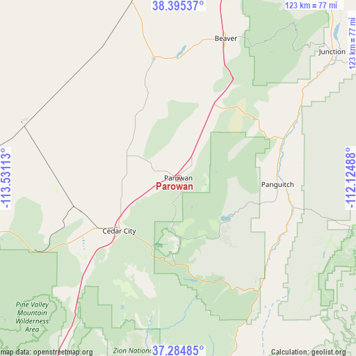
Parowan GPS coordinates[2]
37° 50' 31.92" North, 112° 49' 40.8" West
| Map corner | latitude | longitude |
|---|---|---|
| Upper-left | 38.39537°, | -113.53113° |
| Center: | 37.8422°, | -112.828° |
| Lower-right: | 37.28485°, | -112.12488° |
| Map W x H: | 123.5×123.5 km | = 76.7×76.7mi |
| max Lat: | 71.29058° ⇑62.4% North |
| Parowan: | 37.8422° |
| min Lat: | ⇓37.6% South 19.06759° |
| min Long | Parowan | max Long |
| -171.73463° | -112.828° | -66.98998° |
| W 11.8%⇐ | ⇒88.2% E |
Elevation
Elevation of Parowan is 1835 m = 6020 ft, and this is 1540.2 m = 5053 ft above average elevation for this country.
| Max E: |
3189 m = 10463 ft | 1.4% |
| Parowan | 1835 m 6020 ft | |
| Avg. | 294.8 m = 967 ft | |
Min E: |
-60 m = -197 ft | 98.6% |
See also: United States elevation on elevation.city.
Geographical zone
Parowan is located in North temperate zone (between Tropic of Cancer and the Arctic Circle). Distance of this Northern Tropic circle is 1601.7 km =995.2 mi to South.| Distance of | km | miles | from Parowan |
|---|---|---|---|
| North Pole | 5799.4 | 3603.6 | to North |
| Arctic Circle | 3193.5 | 1984.3 | to North |
| Tropic Cancer | 1601.7 | 995.2 | to South |
| Equator | 4207.7 | 2614.5 | to South |


Nearby cities:
15 places around Parowan: (largest is in red/bold)
• Beaver
51 km =31.7 mi,  18°
18°
• Cedar City
27.5 km =17.1 mi,  228°
228°
• Circleville
61.1 km =38 mi,  53°
53°
• Enoch
18.9 km =11.7 mi,  246°
246°
• Junction
69 km =42.9 mi, 50°
• LaVerkin
81.2 km =50.5 mi,  208°
208°
• Milford
63.7 km =39.6 mi,  345°
345°
• Minersville
42.2 km =26.2 mi, 348°
• Orderville
65.2 km =40.5 mi,  165°
165°
• Panguitch
34.5 km =21.4 mi,  93°
93°
• Paragonah
6.7 km =4.2 mi,  43°
43°
• Springdale
74.2 km =46.1 mi,  191°
191°
• Toquerville
76.9 km =47.8 mi, 211°
• Tropic
69.9 km =43.4 mi,  110°
110°
• Virgin
77.3 km =48 mi,  204°
204°
Sources, notices
• [Note1] Compared only with cities in United States existing in our database
• [Src1] Map data: © OpenStreetMap contributors (CC-BY-SA)
• [Src2] Other city data from geonames.org with taken over terms of usage.
• [Src3] Geographical zone / Annual Mean Temperature by Robert A. Rohde @ Wikipedia
