Enoch geodata
Enoch (Utah) is a populated place; located in United States in America/Denver (GMT-6) time zone. With population of 6,265 people, there are 6235 cities with bigger population in this country. Compared to other cities in United States, 62.8% of cities are located further ↑North; 88.2% of cities are located further →East and 97.9% of cities have lower elevation than Enoch. Note1


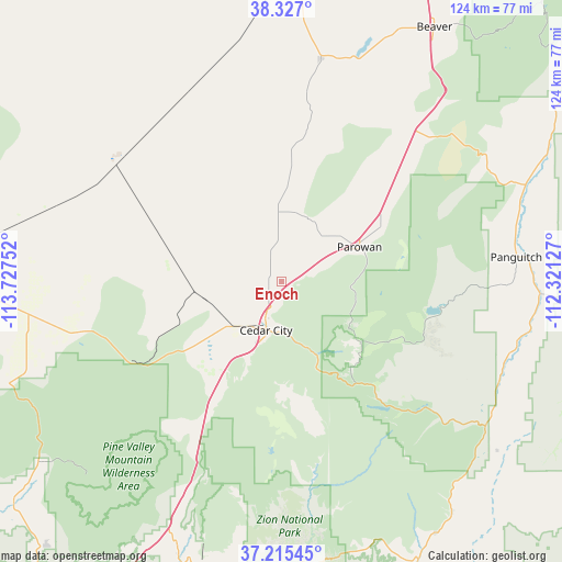
Enoch GPS coordinates[2]
37° 46' 23.916" North, 113° 1' 27.804" West
| Map corner | latitude | longitude |
|---|---|---|
| Upper-left | 38.327°, | -113.72752° |
| Center: | 37.77331°, | -113.02439° |
| Lower-right: | 37.21545°, | -112.32127° |
| Map W x H: | 123.6×123.6 km | = 76.8×76.8mi |
| max Lat: | 71.29058° ⇑62.8% North |
| Enoch: | 37.77331° |
| min Lat: | ⇓37.2% South 19.06759° |
| min Long | Enoch | max Long |
| -171.73463° | -113.02439° | -66.98998° |
| W 11.8%⇐ | ⇒88.2% E |
Elevation
Elevation of Enoch is 1694 m = 5558 ft, and this is 1399.2 m = 4591 ft above average elevation for this country.
| Max E: |
3189 m = 10463 ft | 2.1% |
| Enoch | 1694 m 5558 ft | |
| Avg. | 294.8 m = 967 ft | |
Min E: |
-60 m = -197 ft | 97.9% |
See also: United States elevation on elevation.city.
Geographical zone
Enoch is located in North temperate zone (between Tropic of Cancer and the Arctic Circle). Distance of this Northern Tropic circle is 1594.1 km =990.5 mi to South.| Distance of | km | miles | from Enoch |
|---|---|---|---|
| North Pole | 5807.1 | 3608.4 | to North |
| Arctic Circle | 3201.2 | 1989.1 | to North |
| Tropic Cancer | 1594.1 | 990.5 | to South |
| Equator | 4200 | 2609.8 | to South |


Nearby cities:
15 places around Enoch: (largest is in red/bold)
• Beaver
65.3 km =40.6 mi,  30°
30°
• Cedar City
11.2 km =7 mi,  197°
197°
• Central
66.1 km =41.1 mi,  233°
233°
• Enterprise
65 km =40.4 mi,  250°
250°
• LaVerkin
67.2 km =41.8 mi, 198°
• Leeds
66.4 km =41.3 mi,  206°
206°
• Milford
69.3 km =43.1 mi,  0°
0°
• Minersville
49.8 km =30.9 mi,  10°
10°
• Orderville
65 km =40.4 mi,  148°
148°
• Panguitch
52 km =32.3 mi,  83°
83°
• Paragonah
25.2 km =15.7 mi,  60°
60°
• Parowan
18.9 km =11.7 mi,  66°
66°
• Springdale
65 km =40.4 mi,  177°
177°
• Toquerville
62.2 km =38.6 mi, 201°
• Virgin
64.5 km =40.1 mi,  192°
192°
Sources, notices
• [Note1] Compared only with cities in United States existing in our database
• [Src1] Map data: © OpenStreetMap contributors (CC-BY-SA)
• [Src2] Other city data from geonames.org with taken over terms of usage.
• [Src3] Geographical zone / Annual Mean Temperature by Robert A. Rohde @ Wikipedia
