Saint George geodata
Saint George (Utah) is a populated place; located in United States in America/Denver (GMT-6) time zone. With population of 72,897 people, there are 564 cities with bigger population in this country. Compared to other cities in United States, 65.7% of cities are located further ↑North; 88.3% of cities are located further →East and 92.2% of cities have lower elevation than Saint George. Note1


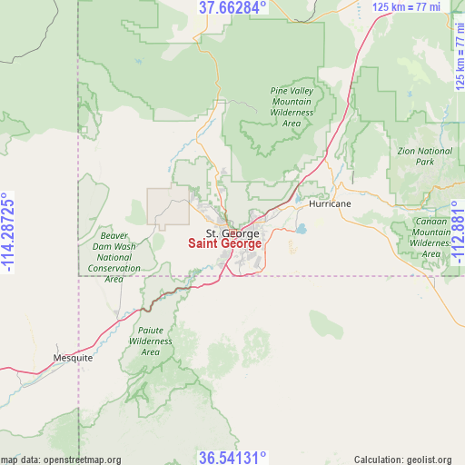
Saint George GPS coordinates[2]
37° 6' 14.94" North, 113° 35' 2.832" West
| Map corner | latitude | longitude |
|---|---|---|
| Upper-left | 37.66284°, | -114.28725° |
| Center: | 37.10415°, | -113.58412° |
| Lower-right: | 36.54131°, | -112.881° |
| Map W x H: | 124.7×124.7 km | = 77.5×77.5mi |
| max Lat: | 71.29058° ⇑65.7% North |
| Saint George: | 37.10415° |
| min Lat: | ⇓34.3% South 19.06759° |
| min Long | Saint George | max Long |
| -171.73463° | -113.58412° | -66.98998° |
| W 11.7%⇐ | ⇒88.3% E |
Elevation
Elevation of Saint George is 825 m = 2707 ft, and this is 530.2 m = 1740 ft above average elevation for this country.
| Max E: |
3189 m = 10463 ft | 7.8% |
| Saint George | 825 m 2707 ft | |
| Avg. | 294.8 m = 967 ft | |
Min E: |
-60 m = -197 ft | 92.2% |
See also: Saint George elevation on elevation.city.
Geographical zone
Saint George is located in North temperate zone (between Tropic of Cancer and the Arctic Circle). Distance of this Northern Tropic circle is 1519.7 km =944.3 mi to South.| Distance of | km | miles | from Saint George |
|---|---|---|---|
| North Pole | 5881.5 | 3654.6 | to North |
| Arctic Circle | 3275.6 | 2035.4 | to North |
| Tropic Cancer | 1519.7 | 944.3 | to South |
| Equator | 4125.6 | 2563.5 | to South |


Nearby cities:
15 places around Saint George: (largest is in red/bold)
• Apple Valley
40.8 km =25.4 mi,  92°
92°
• Beaver Dam
38.4 km =23.9 mi,  233°
233°
• Central
34.9 km =21.7 mi,  354°
354°
• Dammeron Valley
23.6 km =14.7 mi,  341°
341°
• Enterprise
53.5 km =33.2 mi, 347°
• Hurricane
27.2 km =16.9 mi,  73°
73°
• Ivins
11.1 km =6.9 mi,  310°
310°
• LaVerkin
29.9 km =18.6 mi, 68°
• Leeds
24.9 km =15.5 mi,  53°
53°
• Santa Clara
7 km =4.3 mi,  297°
297°
• Scenic
51.4 km =31.9 mi, 227°
• Springdale
52.7 km =32.7 mi,  79°
79°
• Toquerville
31.3 km =19.4 mi,  57°
57°
• Virgin
36.9 km =22.9 mi, 71°
• Washington
7.3 km =4.5 mi, 66°
Sources, notices
• [Note1] Compared only with cities in United States existing in our database
• [Src1] Map data: © OpenStreetMap contributors (CC-BY-SA)
• [Src2] Other city data from geonames.org with taken over terms of usage.
• [Src3] Geographical zone / Annual Mean Temperature by Robert A. Rohde @ Wikipedia
