Santa Clara geodata
Santa Clara (Utah) is a populated place; located in United States in America/Denver (GMT-6) time zone. With population of 6,841 people, there are 5899 cities with bigger population in this country. Compared to other cities in United States, 65.5% of cities are located further ↑North; 88.3% of cities are located further →East and 92.4% of cities have lower elevation than Santa Clara. Note1


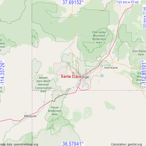
Santa Clara GPS coordinates[2]
37° 7' 58.944" North, 113° 39' 14.868" West
| Map corner | latitude | longitude |
|---|---|---|
| Upper-left | 37.69152°, | -114.35726° |
| Center: | 37.13304°, | -113.65413° |
| Lower-right: | 36.57041°, | -112.95101° |
| Map W x H: | 124.7×124.7 km | = 77.5×77.5mi |
| max Lat: | 71.29058° ⇑65.5% North |
| Santa Clara: | 37.13304° |
| min Lat: | ⇓34.5% South 19.06759° |
| min Long | Santa Clara | max Long |
| -171.73463° | -113.65413° | -66.98998° |
| W 11.7%⇐ | ⇒88.3% E |
Elevation
Elevation of Santa Clara is 848 m = 2782 ft, and this is 553.2 m = 1815 ft above average elevation for this country.
| Max E: |
3189 m = 10463 ft | 7.6% |
| Santa Clara | 848 m 2782 ft | |
| Avg. | 294.8 m = 967 ft | |
Min E: |
-60 m = -197 ft | 92.4% |
See also: United States elevation on elevation.city.
Geographical zone
Santa Clara is located in North temperate zone (between Tropic of Cancer and the Arctic Circle). Distance of this Northern Tropic circle is 1522.9 km =946.3 mi to South.| Distance of | km | miles | from Santa Clara |
|---|---|---|---|
| North Pole | 5878.3 | 3652.6 | to North |
| Arctic Circle | 3272.4 | 2033.4 | to North |
| Tropic Cancer | 1522.9 | 946.3 | to South |
| Equator | 4128.8 | 2565.5 | to South |


Nearby cities:
15 places around Santa Clara: (largest is in red/bold)
• Apple Valley
47.2 km =29.3 mi,  95°
95°
• Beaver Dam
35.9 km =22.3 mi,  223°
223°
• Central
31.6 km =19.6 mi,  4°
4°
• Dammeron Valley
19.2 km =11.9 mi,  355°
355°
• Enterprise
49.3 km =30.6 mi,  353°
353°
• Hurricane
32.6 km =20.3 mi,  81°
81°
• Ivins
4.5 km =2.8 mi,  330°
330°
• LaVerkin
34.9 km =21.7 mi, 77°
• Leeds
28.6 km =17.8 mi,  65°
65°
• Mesquite
51.7 km =32.1 mi,  225°
225°
• Saint George
7 km =4.3 mi,  117°
117°
• Scenic
49.4 km =30.7 mi, 220°
• Toquerville
35.4 km =22 mi, 67°
• Virgin
42.1 km =26.2 mi, 78°
• Washington
12.9 km =8 mi,  91°
91°
Sources, notices
• [Note1] Compared only with cities in United States existing in our database
• [Src1] Map data: © OpenStreetMap contributors (CC-BY-SA)
• [Src2] Other city data from geonames.org with taken over terms of usage.
• [Src3] Geographical zone / Annual Mean Temperature by Robert A. Rohde @ Wikipedia
