Enterprise geodata
Enterprise (Utah) is a populated place; located in United States in America/Denver (GMT-6) time zone. With population of 1,799 people, there are 12541 cities with bigger population in this country. Compared to other cities in United States, 63.8% of cities are located further ↑North; 88.4% of cities are located further →East and 97.5% of cities have lower elevation than Enterprise. Note1


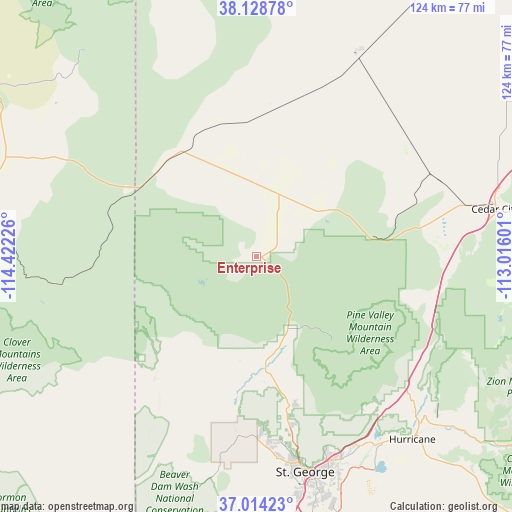
Enterprise GPS coordinates[2]
37° 34' 24.924" North, 113° 43' 8.868" West
| Map corner | latitude | longitude |
|---|---|---|
| Upper-left | 38.12878°, | -114.42226° |
| Center: | 37.57359°, | -113.71913° |
| Lower-right: | 37.01423°, | -113.01601° |
| Map W x H: | 123.9×123.9 km | = 77×77mi |
| max Lat: | 71.29058° ⇑63.8% North |
| Enterprise: | 37.57359° |
| min Lat: | ⇓36.2% South 19.06759° |
| min Long | Enterprise | max Long |
| -171.73463° | -113.71913° | -66.98998° |
| W 11.6%⇐ | ⇒88.4% E |
Elevation
Elevation of Enterprise is 1625 m = 5331 ft, and this is 1330.2 m = 4364 ft above average elevation for this country.
| Max E: |
3189 m = 10463 ft | 2.5% |
| Enterprise | 1625 m 5331 ft | |
| Avg. | 294.8 m = 967 ft | |
Min E: |
-60 m = -197 ft | 97.5% |
See also: United States elevation on elevation.city.
Geographical zone
Enterprise is located in North temperate zone (between Tropic of Cancer and the Arctic Circle). Distance of this Northern Tropic circle is 1571.9 km =976.7 mi to South.| Distance of | km | miles | from Enterprise |
|---|---|---|---|
| North Pole | 5829.3 | 3622.2 | to North |
| Arctic Circle | 3223.4 | 2002.9 | to North |
| Tropic Cancer | 1571.9 | 976.7 | to South |
| Equator | 4177.8 | 2596 | to South |


Nearby cities:
15 places around Enterprise: (largest is in red/bold)
• Caliente
70 km =43.5 mi,  273°
273°
• Cedar City
59 km =36.7 mi,  78°
78°
• Central
19.3 km =12 mi,  154°
154°
• Dammeron Valley
30.1 km =18.7 mi,  171°
171°
• Enoch
65 km =40.4 mi,  70°
70°
• Hurricane
58.3 km =36.2 mi,  139°
139°
• Ivins
45.2 km =28.1 mi,  175°
175°
• LaVerkin
57.4 km =35.7 mi, 136°
• Leeds
49 km =30.4 mi, 139°
• Panaca
63.7 km =39.6 mi,  292°
292°
• Saint George
53.5 km =33.2 mi, 167°
• Santa Clara
49.3 km =30.6 mi, 173°
• Toquerville
52.3 km =32.5 mi,  132°
132°
• Virgin
62 km =38.5 mi, 130°
• Washington
52.7 km =32.7 mi,  159°
159°
Sources, notices
• [Note1] Compared only with cities in United States existing in our database
• [Src1] Map data: © OpenStreetMap contributors (CC-BY-SA)
• [Src2] Other city data from geonames.org with taken over terms of usage.
• [Src3] Geographical zone / Annual Mean Temperature by Robert A. Rohde @ Wikipedia
