Athol geodata
Athol (Idaho) is a populated place; located in United States in America/Los_Angeles (GMT-7) time zone. With population of 696 people, there are 18715 cities with bigger population in this country. Compared to other cities in United States, 98.5% of cities are located further ↓South; 89.5% of cities are located further →East and 91.2% of cities have lower elevation than Athol. Note1


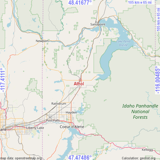
Athol GPS coordinates[2]
47° 56' 52.656" North, 116° 42' 28.692" West
| Map corner | latitude | longitude |
|---|---|---|
| Upper-left | 48.41677°, | -117.4111° |
| Center: | 47.94796°, | -116.70797° |
| Lower-right: | 47.47486°, | -116.00485° |
| Map W x H: | 104.7×104.7 km | = 65.1×65.1mi |
| max Lat: | 71.29058° ⇑1.5% North |
| Athol: | 47.94796° |
| min Lat: | ⇓98.5% South 19.06759° |
| min Long | Athol | max Long |
| -171.73463° | -116.70797° | -66.98998° |
| W 10.5%⇐ | ⇒89.5% E |
Elevation
Elevation of Athol is 727 m = 2385 ft, and this is 432.2 m = 1418 ft above average elevation for this country.
| Max E: |
3189 m = 10463 ft | 8.8% |
| Athol | 727 m 2385 ft | |
| Avg. | 294.8 m = 967 ft | |
Min E: |
-60 m = -197 ft | 91.2% |
See also: United States elevation on elevation.city.
Geographical zone
Athol is located in North temperate zone (between Tropic of Cancer and the Arctic Circle). Distance of this North polar circle is 2069.9 km =1286.2 mi to North.| Distance of | km | miles | from Athol |
|---|---|---|---|
| North Pole | 4675.7 | 2905.3 | to North |
| Arctic Circle | 2069.9 | 1286.2 | to North |
| Tropic Cancer | 2725.4 | 1693.5 | to South |
| Equator | 5331.3 | 3312.7 | to South |


Nearby cities:
15 places around Athol: (largest is in red/bold)
• Coeur d'Alene
30.5 km =19 mi,  190°
190°
• Dalton Gardens
24.7 km =15.3 mi, 190°
• Dover
34.5 km =21.4 mi,  12°
12°
• Hauser
30.8 km =19.1 mi,  230°
230°
• Hayden
21.1 km =13.1 mi,  196°
196°
• Hayden Lake
21.3 km =13.2 mi, 189°
• Kootenai
42.8 km =26.6 mi,  19°
19°
• Newport
35.8 km =22.2 mi,  315°
315°
• Otis Orchards-East Farms
38.4 km =23.9 mi, 226°
• Ponderay
41.8 km =26 mi, 18°
• Post Falls
31.4 km =19.5 mi,  215°
215°
• Priest River
30 km =18.6 mi,  329°
329°
• Rathdrum
20.6 km =12.8 mi, 223°
• Sandpoint
38.3 km =23.8 mi, 17°
• Spirit Lake
12.1 km =7.5 mi,  279°
279°
Sources, notices
• [Note1] Compared only with cities in United States existing in our database
• [Src1] Map data: © OpenStreetMap contributors (CC-BY-SA)
• [Src2] Other city data from geonames.org with taken over terms of usage.
• [Src3] Geographical zone / Annual Mean Temperature by Robert A. Rohde @ Wikipedia
