Bend geodata
Bend (California) is a populated place; located in United States in America/Los_Angeles (GMT-7) time zone. With population of 619 people, there are 19480 cities with bigger population in this country. Compared to other cities in United States, 56.1% of cities are located further ↓South; 95.7% of cities are located further →East and 69.7% of cities have higher elevation than Bend. Note1


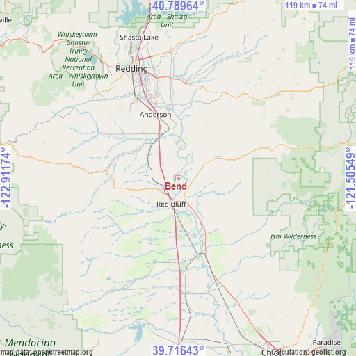
Bend GPS coordinates[2]
40° 15' 18.576" North, 122° 12' 30.996" West
| Map corner | latitude | longitude |
|---|---|---|
| Upper-left | 40.78964°, | -122.91174° |
| Center: | 40.25516°, | -122.20861° |
| Lower-right: | 39.71643°, | -121.50549° |
| Map W x H: | 119.3×119.3 km | = 74.1×74.1mi |
| max Lat: | 71.29058° ⇑43.9% North |
| Bend: | 40.25516° |
| min Lat: | ⇓56.1% South 19.06759° |
| min Long | Bend | max Long |
| -171.73463° | -122.20861° | -66.98998° |
| W 4.3%⇐ | ⇒95.7% E |
Elevation
Elevation of Bend is 102 m = 335 ft, and this is 192.8 m = 633 ft below average elevation for this country.
| Max E: |
3189 m = 10463 ft | 69.7% |
| Avg. | 294.8 m = 967 ft | |
| Bend | 102 m = 335 ft | |
Min E: |
-60 m = -197 ft | 30.3% |
See also: United States elevation on elevation.city.
Geographical zone
Bend is located in North temperate zone (between Tropic of Cancer and the Arctic Circle). Distance of this Northern Tropic circle is 1870 km =1162 mi to South.| Distance of | km | miles | from Bend |
|---|---|---|---|
| North Pole | 5531.1 | 3436.9 | to North |
| Arctic Circle | 2925.2 | 1817.6 | to North |
| Tropic Cancer | 1870 | 1162 | to South |
| Equator | 4476 | 2781.3 | to South |


Nearby cities:
15 places around Bend: (largest is in red/bold)
• Anderson
22.8 km =14.2 mi,  340°
340°
• Bella Vista
42.9 km =26.7 mi,  357°
357°
• Central Valley (historical)
49.2 km =30.6 mi, 343°
• Corning
36.5 km =22.7 mi,  176°
176°
• Cottonwood
15.8 km =9.8 mi, 337°
• Gerber
22.7 km =14.1 mi,  167°
167°
• Los Molinos
27.6 km =17.1 mi,  160°
160°
• Millville
32.8 km =20.4 mi,  4°
4°
• Palo Cedro
34.4 km =21.4 mi, 355°
• Rancho Tehama Reserve
31.2 km =19.4 mi,  211°
211°
• Red Bluff
8.8 km =5.5 mi,  195°
195°
• Redding
40 km =24.9 mi, 337°
• Shasta
45.2 km =28.1 mi,  327°
327°
• Shasta Lake
49.2 km =30.6 mi, 343°
• Shingletown
37.8 km =23.5 mi,  45°
45°
Sources, notices
• [Note1] Compared only with cities in United States existing in our database
• [Src1] Map data: © OpenStreetMap contributors (CC-BY-SA)
• [Src2] Other city data from geonames.org with taken over terms of usage.
• [Src3] Geographical zone / Annual Mean Temperature by Robert A. Rohde @ Wikipedia
