Redding geodata
Redding (California) is a seat of a second-order administrative division; located in United States in America/Los_Angeles (GMT-7) time zone. With population of 91,582 people, there are 403 cities with bigger population in this country. Compared to other cities in United States, 59.9% of cities are located further ↓South; 96.3% of cities are located further →East and 56.8% of cities have higher elevation than Redding. Note1


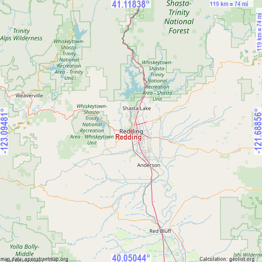
Redding GPS coordinates[2]
40° 35' 11.544" North, 122° 23' 30.048" West
| Map corner | latitude | longitude |
|---|---|---|
| Upper-left | 41.11838°, | -123.09481° |
| Center: | 40.58654°, | -122.39168° |
| Lower-right: | 40.05044°, | -121.68856° |
| Map W x H: | 118.7×118.7 km | = 73.8×73.8mi |
| max Lat: | 71.29058° ⇑40.1% North |
| Redding: | 40.58654° |
| min Lat: | ⇓59.9% South 19.06759° |
| min Long | Redding | max Long |
| -171.73463° | -122.39168° | -66.98998° |
| W 3.7%⇐ | ⇒96.3% E |
Elevation
Elevation of Redding is 172 m = 564 ft, and this is 122.8 m = 403 ft below average elevation for this country.
| Max E: |
3189 m = 10463 ft | 56.8% |
| Avg. | 294.8 m = 967 ft | |
| Redding | 172 m = 564 ft | |
Min E: |
-60 m = -197 ft | 43.2% |
See also: Redding elevation on elevation.city.
Geographical zone
Redding is located in North temperate zone (between Tropic of Cancer and the Arctic Circle). Distance of this Northern Tropic circle is 1906.9 km =1184.9 mi to South.| Distance of | km | miles | from Redding |
|---|---|---|---|
| North Pole | 5494.3 | 3414 | to North |
| Arctic Circle | 2888.4 | 1794.8 | to North |
| Tropic Cancer | 1906.9 | 1184.9 | to South |
| Equator | 4512.8 | 2804.1 | to South |


Nearby cities:
15 places around Redding: (largest is in red/bold)
• Anderson
17.3 km =10.7 mi,  152°
152°
• Bella Vista
14.7 km =9.1 mi,  65°
65°
• Bend
40 km =24.9 mi,  157°
157°
• Central Valley (historical)
10.6 km =6.6 mi,  9°
9°
• Cottonwood
24.2 km =15 mi, 157°
• Douglas City
47.2 km =29.3 mi,  278°
278°
• Lewiston
37.6 km =23.4 mi,  290°
290°
• Millville
18.7 km =11.6 mi,  102°
102°
• Mountain Gate
15.3 km =9.5 mi,  19°
19°
• Palo Cedro
13.2 km =8.2 mi, 101°
• Red Bluff
47.3 km =29.4 mi, 163°
• Shasta
8.6 km =5.3 mi, 279°
• Shasta Lake
10.6 km =6.6 mi, 9°
• Shingletown
43.7 km =27.2 mi, 103°
• Weaverville
49.1 km =30.5 mi, 289°
Sources, notices
• [Note1] Compared only with cities in United States existing in our database
• [Src1] Map data: © OpenStreetMap contributors (CC-BY-SA)
• [Src2] Other city data from geonames.org with taken over terms of usage.
• [Src3] Geographical zone / Annual Mean Temperature by Robert A. Rohde @ Wikipedia
