Shasta geodata
Shasta (California) is a populated place; located in United States in America/Los_Angeles (GMT-7) time zone. With population of 1,771 people, there are 12665 cities with bigger population in this country. Compared to other cities in United States, 60% of cities are located further ↓South; 96.6% of cities are located further →East and 76.3% of cities have lower elevation than Shasta. Note1


Shasta GPS coordinates[2]
40° 35' 57.552" North, 122° 29' 31.056" West
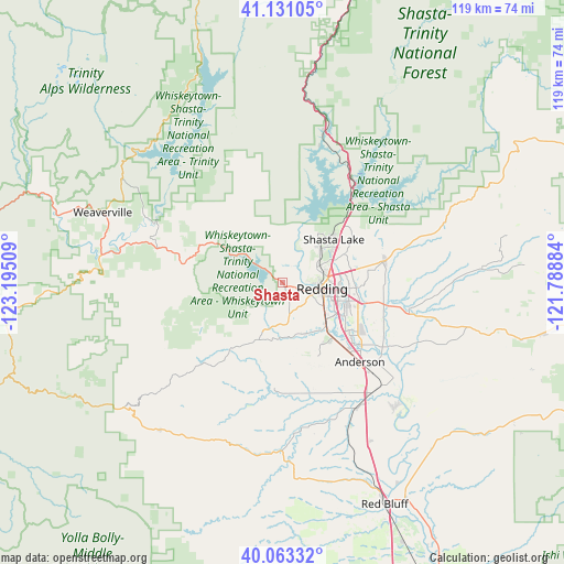
| Map corner | latitude | longitude |
|---|---|---|
| Upper-left | 41.13105°, | -123.19509° |
| Center: | 40.59932°, | -122.49196° |
| Lower-right: | 40.06332°, | -121.78884° |
| Map W x H: | 118.7×118.7 km | = 73.8×73.8mi |
| max Lat: | 71.29058° ⇑40% North |
| Shasta: | 40.59932° |
| min Lat: | ⇓60% South 19.06759° |
| min Long | Shasta | max Long |
| -171.73463° | -122.49196° | -66.98998° |
| W 3.4%⇐ | ⇒96.6% E |
Elevation
Elevation of Shasta is 322 m = 1056 ft, and this is 27.2 m = 89 ft above average elevation for this country.
| Max E: |
3189 m = 10463 ft | 23.7% |
| Shasta | 322 m 1056 ft | |
| Avg. | 294.8 m = 967 ft | |
Min E: |
-60 m = -197 ft | 76.3% |
See also: United States elevation on elevation.city.
Geographical zone
Shasta is located in North temperate zone (between Tropic of Cancer and the Arctic Circle). Distance of this Northern Tropic circle is 1908.3 km =1185.8 mi to South.| Distance of | km | miles | from Shasta |
|---|---|---|---|
| North Pole | 5492.8 | 3413.1 | to North |
| Arctic Circle | 2887 | 1793.9 | to North |
| Tropic Cancer | 1908.3 | 1185.8 | to South |
| Equator | 4514.2 | 2805 | to South |


Nearby cities:
15 places around Shasta: (largest is in red/bold)
• Anderson
23.5 km =14.6 mi,  135°
135°
• Bella Vista
22.4 km =13.9 mi,  78°
78°
• Bend
45.2 km =28.1 mi,  147°
147°
• Central Valley (historical)
13.6 km =8.5 mi,  48°
48°
• Cottonwood
29.7 km =18.5 mi, 143°
• Douglas City
38.7 km =24 mi,  278°
278°
• Junction City
49.7 km =30.9 mi,  287°
287°
• Lewiston
29.2 km =18.1 mi, 294°
• Millville
27.3 km =17 mi,  101°
101°
• Mountain Gate
18.8 km =11.7 mi, 46°
• Palo Cedro
21.7 km =13.5 mi, 100°
• Red Bluff
51.6 km =32.1 mi,  155°
155°
• Redding
8.6 km =5.3 mi, 99°
• Shasta Lake
13.6 km =8.5 mi, 48°
• Weaverville
40.7 km =25.3 mi, 291°
Sources, notices
• [Note1] Compared only with cities in United States existing in our database
• [Src1] Map data: © OpenStreetMap contributors (CC-BY-SA)
• [Src2] Other city data from geonames.org with taken over terms of usage.
• [Src3] Geographical zone / Annual Mean Temperature by Robert A. Rohde @ Wikipedia
