Fort Jones geodata
Fort Jones (California) is a populated place; located in United States in America/Los_Angeles (GMT-7) time zone. With population of 688 people, there are 18795 cities with bigger population in this country. Compared to other cities in United States, 71.9% of cities are located further ↓South; 97.6% of cities are located further →East and 92.4% of cities have lower elevation than Fort Jones. Note1


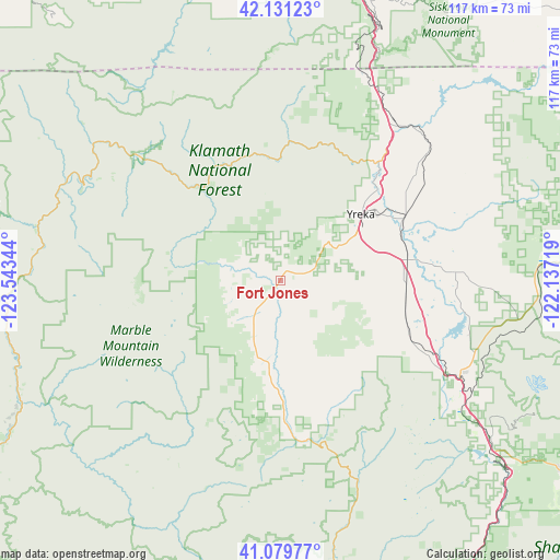
Fort Jones GPS coordinates[2]
41° 36' 27.504" North, 122° 50' 25.116" West
| Map corner | latitude | longitude |
|---|---|---|
| Upper-left | 42.13123°, | -123.54344° |
| Center: | 41.60764°, | -122.84031° |
| Lower-right: | 41.07977°, | -122.13719° |
| Map W x H: | 116.9×116.9 km | = 72.6×72.6mi |
| max Lat: | 71.29058° ⇑28.1% North |
| Fort Jones: | 41.60764° |
| min Lat: | ⇓71.9% South 19.06759° |
| min Long | Fort Jones | max Long |
| -171.73463° | -122.84031° | -66.98998° |
| W 2.4%⇐ | ⇒97.6% E |
Elevation
Elevation of Fort Jones is 843 m = 2766 ft, and this is 548.2 m = 1799 ft above average elevation for this country.
| Max E: |
3189 m = 10463 ft | 7.6% |
| Fort Jones | 843 m 2766 ft | |
| Avg. | 294.8 m = 967 ft | |
Min E: |
-60 m = -197 ft | 92.4% |
See also: United States elevation on elevation.city.
Geographical zone
Fort Jones is located in North temperate zone (between Tropic of Cancer and the Arctic Circle). Distance of this Northern Tropic circle is 2020.4 km =1255.4 mi to South.| Distance of | km | miles | from Fort Jones |
|---|---|---|---|
| North Pole | 5380.7 | 3343.4 | to North |
| Arctic Circle | 2774.8 | 1724.2 | to North |
| Tropic Cancer | 2020.4 | 1255.4 | to South |
| Equator | 4626.3 | 2874.6 | to South |


Nearby cities:
15 places around Fort Jones: (largest is in red/bold)
• Ashland
66.2 km =41.1 mi,  9°
9°
• Dunsmuir
65 km =40.4 mi,  133°
133°
• Etna
17.4 km =10.8 mi,  195°
195°
• Happy Camp
49.4 km =30.7 mi,  294°
294°
• Jacksonville
79.2 km =49.2 mi,  352°
352°
• McCloud
70.3 km =43.7 mi,  123°
123°
• Medford
80 km =49.7 mi,  357°
357°
• Montague
29.2 km =18.1 mi,  62°
62°
• Mount Shasta
55 km =34.2 mi, 126°
• Phoenix
74.3 km =46.2 mi,  1°
1°
• Ruch
72.8 km =45.2 mi, 347°
• Talent
71.1 km =44.2 mi, 3°
• Weed
43 km =26.7 mi, 118°
• Williams
76.8 km =47.7 mi,  332°
332°
• Yreka
22.2 km =13.8 mi,  50°
50°
Sources, notices
• [Note1] Compared only with cities in United States existing in our database
• [Src1] Map data: © OpenStreetMap contributors (CC-BY-SA)
• [Src2] Other city data from geonames.org with taken over terms of usage.
• [Src3] Geographical zone / Annual Mean Temperature by Robert A. Rohde @ Wikipedia
