Loveland geodata
Loveland (Colorado) is a populated place; located in United States in America/Denver (GMT-6) time zone. With population of 75,182 people, there are 538 cities with bigger population in this country. Compared to other cities in United States, 57.9% of cities are located further ↓South; 83.4% of cities are located further →East and 96.9% of cities have lower elevation than Loveland. Note1


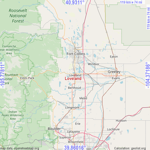
Loveland GPS coordinates[2]
40° 23' 51.936" North, 105° 4' 29.928" West
| Map corner | latitude | longitude |
|---|---|---|
| Upper-left | 40.9311°, | -105.77811° |
| Center: | 40.39776°, | -105.07498° |
| Lower-right: | 39.86016°, | -104.37186° |
| Map W x H: | 119.1×119.1 km | = 74×74mi |
| max Lat: | 71.29058° ⇑42.1% North |
| Loveland: | 40.39776° |
| min Lat: | ⇓57.9% South 19.06759° |
| min Long | Loveland | max Long |
| -171.73463° | -105.07498° | -66.98998° |
| W 16.6%⇐ | ⇒83.4% E |
Elevation
Elevation of Loveland is 1522 m = 4993 ft, and this is 1227.2 m = 4026 ft above average elevation for this country.
| Max E: |
3189 m = 10463 ft | 3.1% |
| Loveland | 1522 m 4993 ft | |
| Avg. | 294.8 m = 967 ft | |
Min E: |
-60 m = -197 ft | 96.9% |
See also: Loveland elevation on elevation.city.
Geographical zone
Loveland is located in North temperate zone (between Tropic of Cancer and the Arctic Circle). Distance of this Northern Tropic circle is 1885.9 km =1171.8 mi to South.| Distance of | km | miles | from Loveland |
|---|---|---|---|
| North Pole | 5515.3 | 3427 | to North |
| Arctic Circle | 2909.4 | 1807.8 | to North |
| Tropic Cancer | 1885.9 | 1171.8 | to South |
| Equator | 4491.8 | 2791.1 | to South |


Nearby cities:
15 places around Loveland: (largest is in red/bold)
• Berthoud
10 km =6.2 mi,  182°
182°
• Campion
5.4 km =3.4 mi, 182°
• Fort Collins
20.9 km =13 mi,  357°
357°
• Gilcrest
28.3 km =17.6 mi,  117°
117°
• Greeley
31.1 km =19.3 mi,  84°
84°
• Johnstown
15.4 km =9.6 mi, 116°
• Laporte
26 km =16.2 mi,  347°
347°
• Longmont
25.7 km =16 mi,  185°
185°
• Lyons
25.4 km =15.8 mi,  220°
220°
• Mead
19.4 km =12.1 mi,  160°
160°
• Milliken
20.1 km =12.5 mi,  112°
112°
• Platteville
29.5 km =18.3 mi,  133°
133°
• Severance
23.6 km =14.7 mi,  53°
53°
• Timnath
16.5 km =10.3 mi,  27°
27°
• Windsor
17.2 km =10.7 mi,  58°
58°
Sources, notices
• [Note1] Compared only with cities in United States existing in our database
• [Src1] Map data: © OpenStreetMap contributors (CC-BY-SA)
• [Src2] Other city data from geonames.org with taken over terms of usage.
• [Src3] Geographical zone / Annual Mean Temperature by Robert A. Rohde @ Wikipedia
