Sandpoint geodata
Sandpoint (Idaho) is a seat of a second-order administrative division; located in United States in America/Los_Angeles (GMT-7) time zone. With population of 7,835 people, there are 5368 cities with bigger population in this country. Compared to other cities in United States, 98.9% of cities are located further ↓South; 89.4% of cities are located further →East and 90.2% of cities have lower elevation than Sandpoint. Note1


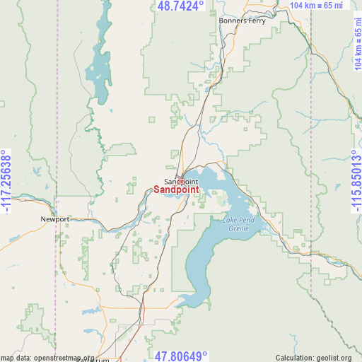
Sandpoint GPS coordinates[2]
48° 16' 35.724" North, 116° 33' 11.7" West
| Map corner | latitude | longitude |
|---|---|---|
| Upper-left | 48.7424°, | -117.25638° |
| Center: | 48.27659°, | -116.55325° |
| Lower-right: | 47.80649°, | -115.85013° |
| Map W x H: | 104.1×104.1 km | = 64.7×64.7mi |
| max Lat: | 71.29058° ⇑1.1% North |
| Sandpoint: | 48.27659° |
| min Lat: | ⇓98.9% South 19.06759° |
| min Long | Sandpoint | max Long |
| -171.73463° | -116.55325° | -66.98998° |
| W 10.6%⇐ | ⇒89.4% E |
Elevation
Elevation of Sandpoint is 641 m = 2103 ft, and this is 346.2 m = 1136 ft above average elevation for this country.
| Max E: |
3189 m = 10463 ft | 9.8% |
| Sandpoint | 641 m 2103 ft | |
| Avg. | 294.8 m = 967 ft | |
Min E: |
-60 m = -197 ft | 90.2% |
See also: United States elevation on elevation.city.
Geographical zone
Sandpoint is located in North temperate zone (between Tropic of Cancer and the Arctic Circle). Distance of this North polar circle is 2033.3 km =1263.4 mi to North.| Distance of | km | miles | from Sandpoint |
|---|---|---|---|
| North Pole | 4639.2 | 2882.7 | to North |
| Arctic Circle | 2033.3 | 1263.4 | to North |
| Tropic Cancer | 2761.9 | 1716.2 | to South |
| Equator | 5367.9 | 3335.5 | to South |


Nearby cities:
15 places around Sandpoint: (largest is in red/bold)
• Athol
38.3 km =23.8 mi,  197°
197°
• Bonners Ferry
49.3 km =30.6 mi,  20°
20°
• Clark Fork
31.6 km =19.6 mi,  117°
117°
• Dalton Gardens
62.9 km =39.1 mi,  194°
194°
• Dover
5.1 km =3.2 mi,  236°
236°
• Hayden
59.4 km =36.9 mi, 196°
• Hayden Lake
59.5 km =37 mi, 194°
• Kootenai
4.8 km =3 mi,  38°
38°
• Moyie Springs
56.8 km =35.3 mi,  28°
28°
• Newport
37.9 km =23.5 mi,  253°
253°
• Ponderay
3.5 km =2.2 mi, 24°
• Priest River
28.6 km =17.8 mi, 248°
• Rathdrum
57.6 km =35.8 mi,  206°
206°
• Spirit Lake
41.7 km =25.9 mi, 214°
• Troy
53.2 km =33.1 mi,  67°
67°
Sources, notices
• [Note1] Compared only with cities in United States existing in our database
• [Src1] Map data: © OpenStreetMap contributors (CC-BY-SA)
• [Src2] Other city data from geonames.org with taken over terms of usage.
• [Src3] Geographical zone / Annual Mean Temperature by Robert A. Rohde @ Wikipedia
