Carlton geodata
Carlton (Montana) is a populated place; located in United States in America/Denver (GMT-6) time zone. With population of 694 people, there are 18733 cities with bigger population in this country. Compared to other cities in United States, 96.1% of cities are located further ↓South; 88.5% of cities are located further →East and 93.3% of cities have lower elevation than Carlton. Note1


Carlton GPS coordinates[2]
46° 40' 32.736" North, 114° 4' 43.392" West
| Map corner | latitude | longitude |
|---|---|---|
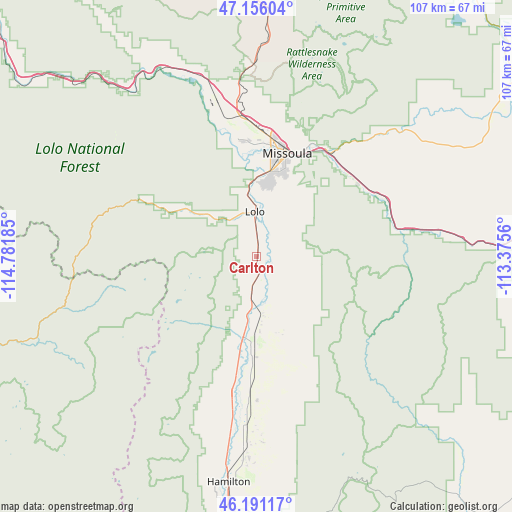
| Upper-left | 47.15604°, | -114.78185° |
| Center: | 46.67576°, | -114.07872° |
| Lower-right: | 46.19117°, | -113.3756° |
| Map W x H: | 107.3×107.3 km | = 66.7×66.7mi |
| max Lat: | 71.29058° ⇑3.9% North |
| Carlton: | 46.67576° |
| min Lat: | ⇓96.1% South 19.06759° |
| min Long | Carlton | max Long |
| -171.73463° | -114.07872° | -66.98998° |
| W 11.5%⇐ | ⇒88.5% E |
Elevation
Elevation of Carlton is 980 m = 3215 ft, and this is 685.2 m = 2248 ft above average elevation for this country.
| Max E: |
3189 m = 10463 ft | 6.7% |
| Carlton | 980 m 3215 ft | |
| Avg. | 294.8 m = 967 ft | |
Min E: |
-60 m = -197 ft | 93.3% |
See also: United States elevation on elevation.city.
Geographical zone
Carlton is located in North temperate zone (between Tropic of Cancer and the Arctic Circle). Distance of this North polar circle is 2211.3 km =1374 mi to North.| Distance of | km | miles | from Carlton |
|---|---|---|---|
| North Pole | 4817.2 | 2993.3 | to North |
| Arctic Circle | 2211.3 | 1374 | to North |
| Tropic Cancer | 2583.9 | 1605.6 | to South |
| Equator | 5189.9 | 3224.9 | to South |


Nearby cities:
15 places around Carlton: (largest is in red/bold)
• Arlee
54.1 km =33.6 mi,  359°
359°
• Bonner-West Riverside
26.7 km =16.6 mi,  33°
33°
• Clinton
29.8 km =18.5 mi,  69°
69°
• Corvallis
40.3 km =25 mi,  183°
183°
• East Missoula
24 km =14.9 mi, 25°
• Florence
4.9 km =3 mi, 180°
• Frenchtown
39.4 km =24.5 mi,  343°
343°
• Hamilton
48.1 km =29.9 mi,  187°
187°
• Lolo
9.2 km =5.7 mi, 358°
• Missoula
22.8 km =14.2 mi,  16°
16°
• Orchard Homes
21 km =13 mi,  6°
6°
• Pinesdale
39.9 km =24.8 mi,  195°
195°
• Stevensville
18.5 km =11.5 mi, 183°
• Victor
29.3 km =18.2 mi, 190°
• Wye
31 km =19.3 mi,  353°
353°
Sources, notices
• [Note1] Compared only with cities in United States existing in our database
• [Src1] Map data: © OpenStreetMap contributors (CC-BY-SA)
• [Src2] Other city data from geonames.org with taken over terms of usage.
• [Src3] Geographical zone / Annual Mean Temperature by Robert A. Rohde @ Wikipedia
