Missoula geodata
Missoula (Montana) is a seat of a second-order administrative division; located in United States in America/Denver (GMT-6) time zone. With population of 71,022 people, there are 588 cities with bigger population in this country. Compared to other cities in United States, 96.4% of cities are located further ↓South; 88.4% of cities are located further →East and 93.3% of cities have lower elevation than Missoula. Note1


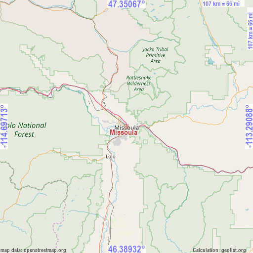
Missoula GPS coordinates[2]
46° 52' 19.74" North, 113° 59' 38.4" West
| Map corner | latitude | longitude |
|---|---|---|
| Upper-left | 47.35067°, | -114.69713° |
| Center: | 46.87215°, | -113.994° |
| Lower-right: | 46.38932°, | -113.29088° |
| Map W x H: | 106.9×106.9 km | = 66.4×66.4mi |
| max Lat: | 71.29058° ⇑3.6% North |
| Missoula: | 46.87215° |
| min Lat: | ⇓96.4% South 19.06759° |
| min Long | Missoula | max Long |
| -171.73463° | -113.994° | -66.98998° |
| W 11.6%⇐ | ⇒88.4% E |
Elevation
Elevation of Missoula is 978 m = 3209 ft, and this is 683.2 m = 2241 ft above average elevation for this country.
| Max E: |
3189 m = 10463 ft | 6.7% |
| Missoula | 978 m 3209 ft | |
| Avg. | 294.8 m = 967 ft | |
Min E: |
-60 m = -197 ft | 93.3% |
See also: Missoula elevation on elevation.city.
Geographical zone
Missoula is located in North temperate zone (between Tropic of Cancer and the Arctic Circle). Distance of this North polar circle is 2189.5 km =1360.5 mi to North.| Distance of | km | miles | from Missoula |
|---|---|---|---|
| North Pole | 4795.4 | 2979.7 | to North |
| Arctic Circle | 2189.5 | 1360.5 | to North |
| Tropic Cancer | 2605.8 | 1619.2 | to South |
| Equator | 5211.7 | 3238.4 | to South |


Nearby cities:
15 places around Missoula: (largest is in red/bold)
• Arlee
32.9 km =20.4 mi,  347°
347°
• Bonner-West Riverside
8.2 km =5.1 mi,  86°
86°
• Carlton
22.8 km =14.2 mi,  196°
196°
• Clinton
24.3 km =15.1 mi,  118°
118°
• Corvallis
62.7 km =39 mi,  188°
188°
• East Missoula
3.8 km =2.4 mi, 92°
• Florence
27.5 km =17.1 mi, 193°
• Frenchtown
23.9 km =14.9 mi,  311°
311°
• Lolo
14.2 km =8.8 mi,  207°
207°
• Orchard Homes
4.3 km =2.7 mi,  256°
256°
• Saint Ignatius
50.4 km =31.3 mi, 351°
• Seeley Lake
51.6 km =32.1 mi,  48°
48°
• Stevensville
41 km =25.5 mi, 190°
• Victor
52 km =32.3 mi, 193°
• Wye
13.2 km =8.2 mi, 312°
Sources, notices
• [Note1] Compared only with cities in United States existing in our database
• [Src1] Map data: © OpenStreetMap contributors (CC-BY-SA)
• [Src2] Other city data from geonames.org with taken over terms of usage.
• [Src3] Geographical zone / Annual Mean Temperature by Robert A. Rohde @ Wikipedia
