Deer Lodge geodata
Deer Lodge (Montana) is a seat of a second-order administrative division; located in United States in America/Denver (GMT-6) time zone. With population of 2,965 people, there are 9696 cities with bigger population in this country. Compared to other cities in United States, 95.6% of cities are located further ↓South; 88.1% of cities are located further →East and 95.9% of cities have lower elevation than Deer Lodge. Note1


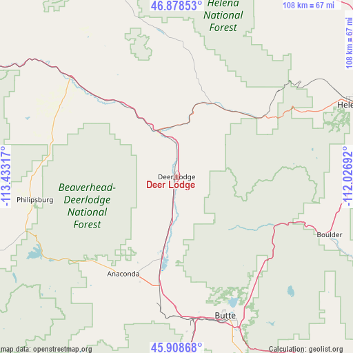
Deer Lodge GPS coordinates[2]
46° 23' 44.736" North, 112° 43' 48.144" West
| Map corner | latitude | longitude |
|---|---|---|
| Upper-left | 46.87853°, | -113.43317° |
| Center: | 46.39576°, | -112.73004° |
| Lower-right: | 45.90868°, | -112.02692° |
| Map W x H: | 107.8×107.8 km | = 67×67mi |
| max Lat: | 71.29058° ⇑4.4% North |
| Deer Lodge: | 46.39576° |
| min Lat: | ⇓95.6% South 19.06759° |
| min Long | Deer Lodge | max Long |
| -171.73463° | -112.73004° | -66.98998° |
| W 11.9%⇐ | ⇒88.1% E |
Elevation
Elevation of Deer Lodge is 1393 m = 4570 ft, and this is 1098.2 m = 3603 ft above average elevation for this country.
| Max E: |
3189 m = 10463 ft | 4.1% |
| Deer Lodge | 1393 m 4570 ft | |
| Avg. | 294.8 m = 967 ft | |
Min E: |
-60 m = -197 ft | 95.9% |
See also: United States elevation on elevation.city.
Geographical zone
Deer Lodge is located in North temperate zone (between Tropic of Cancer and the Arctic Circle). Distance of this North polar circle is 2242.4 km =1393.4 mi to North.| Distance of | km | miles | from Deer Lodge |
|---|---|---|---|
| North Pole | 4848.3 | 3012.6 | to North |
| Arctic Circle | 2242.4 | 1393.4 | to North |
| Tropic Cancer | 2552.8 | 1586.2 | to South |
| Equator | 5158.7 | 3205.5 | to South |


Nearby cities:
15 places around Deer Lodge: (largest is in red/bold)
• Anaconda
33.9 km =21.1 mi,  208°
208°
• Boulder
50 km =31.1 mi,  110°
110°
• Butte
46.1 km =28.6 mi,  160°
160°
• Butte-Silver Bow (Balance)
55.2 km =34.3 mi,  174°
174°
• Clancy
57.5 km =35.7 mi,  82°
82°
• Helena
57.5 km =35.7 mi,  67°
67°
• Helena Valley Northwest
63 km =39.1 mi,  54°
54°
• Helena Valley West Central
59.2 km =36.8 mi,  59°
59°
• Helena West Side
52.2 km =32.4 mi, 64°
• Lincoln
62.3 km =38.7 mi,  3°
3°
• Montana City
63.1 km =39.2 mi, 75°
• Philipsburg
43.9 km =27.3 mi,  260°
260°
• South Hills
58.9 km =36.6 mi, 72°
• Walkerville
42.9 km =26.7 mi, 159°
• Warm Springs
24.2 km =15 mi,  189°
189°
Sources, notices
• [Note1] Compared only with cities in United States existing in our database
• [Src1] Map data: © OpenStreetMap contributors (CC-BY-SA)
• [Src2] Other city data from geonames.org with taken over terms of usage.
• [Src3] Geographical zone / Annual Mean Temperature by Robert A. Rohde @ Wikipedia
