Butte geodata
Butte (Montana) is a seat of a second-order administrative division; located in United States in America/Denver (GMT-6) time zone. With population of 34,190 people, there are 1439 cities with bigger population in this country. Compared to other cities in United States, 95.1% of cities are located further ↓South; 88.1% of cities are located further →East and 97.9% of cities have lower elevation than Butte. Note1


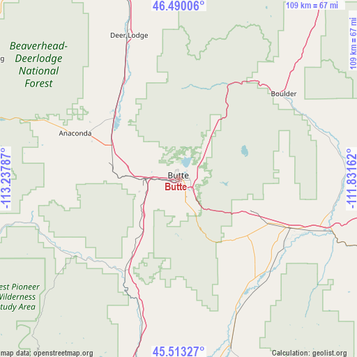
Butte GPS coordinates[2]
46° 0' 13.752" North, 112° 32' 5.064" West
| Map corner | latitude | longitude |
|---|---|---|
| Upper-left | 46.49006°, | -113.23787° |
| Center: | 46.00382°, | -112.53474° |
| Lower-right: | 45.51327°, | -111.83162° |
| Map W x H: | 108.6×108.6 km | = 67.5×67.5mi |
| max Lat: | 71.29058° ⇑4.9% North |
| Butte: | 46.00382° |
| min Lat: | ⇓95.1% South 19.06759° |
| min Long | Butte | max Long |
| -171.73463° | -112.53474° | -66.98998° |
| W 11.9%⇐ | ⇒88.1% E |
Elevation
Elevation of Butte is 1690 m = 5545 ft, and this is 1395.2 m = 4577 ft above average elevation for this country.
| Max E: |
3189 m = 10463 ft | 2.1% |
| Butte | 1690 m 5545 ft | |
| Avg. | 294.8 m = 967 ft | |
Min E: |
-60 m = -197 ft | 97.9% |
See also: United States elevation on elevation.city.
Geographical zone
Butte is located in North temperate zone (between Tropic of Cancer and the Arctic Circle). Distance of this North polar circle is 2286 km =1420.5 mi to North.| Distance of | km | miles | from Butte |
|---|---|---|---|
| North Pole | 4891.9 | 3039.7 | to North |
| Arctic Circle | 2286 | 1420.5 | to North |
| Tropic Cancer | 2509.2 | 1559.1 | to South |
| Equator | 5115.1 | 3178.4 | to South |


Nearby cities:
15 places around Butte: (largest is in red/bold)
• Anaconda
34.4 km =21.4 mi,  293°
293°
• Boulder
41.1 km =25.5 mi,  50°
50°
• Butte-Silver Bow (Balance)
14.8 km =9.2 mi,  219°
219°
• Clancy
66.4 km =41.3 mi,  39°
39°
• Deer Lodge
46.1 km =28.6 mi,  340°
340°
• Helena
75.9 km =47.2 mi,  30°
30°
• Helena West Side
73.5 km =45.7 mi, 26°
• Montana City
75.3 km =46.8 mi, 37°
• Philipsburg
68.9 km =42.8 mi,  301°
301°
• Sheridan
66.4 km =41.3 mi,  156°
156°
• South Hills
74 km =46 mi, 33°
• Three Forks
77 km =47.8 mi,  99°
99°
• Walkerville
3.4 km =2.1 mi,  358°
358°
• Warm Springs
27.6 km =17.1 mi,  315°
315°
• Whitehall
36.9 km =22.9 mi,  113°
113°
Sources, notices
• [Note1] Compared only with cities in United States existing in our database
• [Src1] Map data: © OpenStreetMap contributors (CC-BY-SA)
• [Src2] Other city data from geonames.org with taken over terms of usage.
• [Src3] Geographical zone / Annual Mean Temperature by Robert A. Rohde @ Wikipedia
